Xc Title
User:Guest
Cloudbase Paragliding advert
Hugh Burnaby-Atkins  All flights
National League 2016
Flight type image
Turnpoint Flight on a Paraglider
Club
Thames Valley
Glider
Advance Sigma 9
Date
14th May 2016
Start
13:25
Finish
15:11
Duration
1hr 45mins
Takeoff
Corndon
Landing
Nr Walton
Coords
Takeoff
52.56598, -3.02485
Start
52.56598, -3.02577
TP1
52.56753, -3.01947
TP2
52.51270, -2.99217
TP3
52.22318, -3.08732
Finish
52.23058, -3.07882
Landing
52.23055, -3.07882
Distances and Score
Leg 1
0.46k
Leg 2
6.38k
Leg 3
32.86k
Leg 4
1.01k
Total
40.71k
Score
40.7
Open Distance
Total
38.6k
Filename
Use full pilot name
Download
Validated
Yes
Flight map
Notes

This map gives an overview of the flight, using the turnpoints to plot the track.

Use the for a detailed map and flight track.

Duration 0:00   Takeoff Distance 0
Controls
To animate the flight: click a point on the track, use the slider, or click the Play button.
slider
slider
Speed
Speed
Slower
Faster
Track color
No data
Highlights
Track data
Time: No data
Height:
Climb:
Speed:
Interval:
Units
Height: metres
Climb: m/sec
Speed: km/h
Distance: km
chart
Notes

Climb and Speed averaged over 10 second intervals.

These values may be lower than those shown by a flight instrument, which has access to continuous raw data.

Metric units are used for all chart data, except for Height which is shown in feet.

Height   -   Pressure data
Maximum Height
[14:38:57]
4774 ft
Lowest Save
[13:57:11]
1949 ft
Takeoff Height
[13:25:07]
1447 ft
Landing Height
[15:11:21]
387 ft
Total Ascent 11486 ft
Height Gain
Above Takeoff 3327 ft
Maximum 3402 ft
Low Point
[13:26:27]
1371 ft
High Point
as Maximum Height
4774 ft
Units
Climb   -   Pressure data
Maximum Climb
[14:02:32]
4.4 m/s
Minimum Climb
[14:59:19]
-3.0 m/s
Units
Speed
Maximum Speed
[14:40:37]
59.0 km/h
Average Speed
around course
23.1 km/h
Average Speed
over track length
31.3 km/h
Units
Tracklog
Flight Duration 1hr 46mins
Track Points 637
Recording Interval 10 secs
Statistics Interval 10 secs
Track Length 55.5 km
Units
Flight instrument   -   reported as
6020 SN06475 SW3.07
Notes

Climb and Speed averaged over 10 second intervals.

These values may be lower than those shown by a flight instrument, which has access to continuous raw data.

Average Speed around course is measured from Start to Finish points.

Track Length is the cumulative distance between track points from Takeoff to Landing.

You can change the default units displayed - see the Options page.

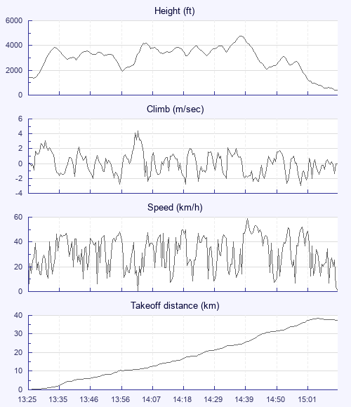
Second time on Corndon and first on the north side. Arrived to find it deserted - though local pilot Neil on an Omega XA turned up after a while - but no others. A tricky site on that side - as quite shallow - and I had a couple of tangles with the heather and a walk up before getting pulled round to the north side where the sun was shining and a strong climb quickly put me at 3.5k. I'd been slightly lacking a plan (having thought of going to Long Mountain at first, so had already switched once) but vaguely thought of flying towards Hereford to get the train back but only if the wind cooperated as it was forecast to have a bit of west in it. The thermals were strong, though it took the biggest (> 5ms-1 up on the averager) to get through the inversion around 4k. By the time I finally made up my mind for Hereford I'd tracked a bit off course; and with easy climbs I'd got lazy. So when it got a bit trickier I wasn't focused properly and was beginning to think about flying cross-wind. First mistake was not to stick with the penultimate climb longer - but I'm still trying to find ways to find the best climbs and not get side-tracked by weaker stuff - so left it and went on… Without success. The area is also higher than Thames Valley so I hadn't factored in that 3k here is not the same as 3k further south in terms of height AGL - so less room to search. I almost made it over the quarry at Old Radnor - but just as I arrived, low, I saw a buzzard in the field to the left. I think if I had stayed over that field, I might just have soared up the side of a small slope and got away, but I tried instead to track back with it hoping it would connect with something coming off the quarry. Alas I lacked the height and realized I had been flushed between the quarry and the slope. I almost made it back and onto the slope, which I soared for three or four beats. It would have been the lowest save ever. But it was not to be. Not a bad flight but could have been much longer - as the big guns further north proved in the NS Cup. Chapeau! To the awesome flights made by the Tinto crew. Three kind souls gave me lifts back, including Paul Massey's wife who generously went out of her way to run me the last bit back to my car. Thanks v much indeed and small donation made to WMAA in lieu of a fuel contribution as promised.

Use this page to set various display Options. You can choose which units are used to display flight data, which map to show when the starts and which tab to show each time you view a flight.
Units settings

Metric units are used by default for the Statistics and XC Player pages, except for Height data which is shown in feet. You can choose your own custom settings here.

Height:
Speed:
Climb:
Distance:
  Use default
XC Player settings

When the XC Player starts, the track data is shown on the Hybrid map. You can choose a different map here.

Main Map:
  Use default
Tab settings

The first tab shown when you view a flight is the Flight Map. You can choose a different tab here.

First Tab:
  Use default
Notes

This page uses cookies to save your settings for future visits.

If you have disabled cookies for this site then any changes you make will not be saved.