


It might not be in completely the correct order.
1st pilot to climb out was Ali Andrews who went on his own.
Next cycle was joe, myself and another bloke on a cure. The guy on the cure decided to leave us and head back to the hill. Not sure why, only explanation I can think of is that my plan had been to leave a little later as rasp had suggested the day would be good until gone 5pm (I think someone did a similar distance to me landing nearly around 6pm). The sky was still fairly blue at the point so maybe that was in his thinking.
That said I'm totally shit at sticking to a flight plan and when i get near base and am intending to go xc who would have the discipline fly back anyway? Certainly not me.
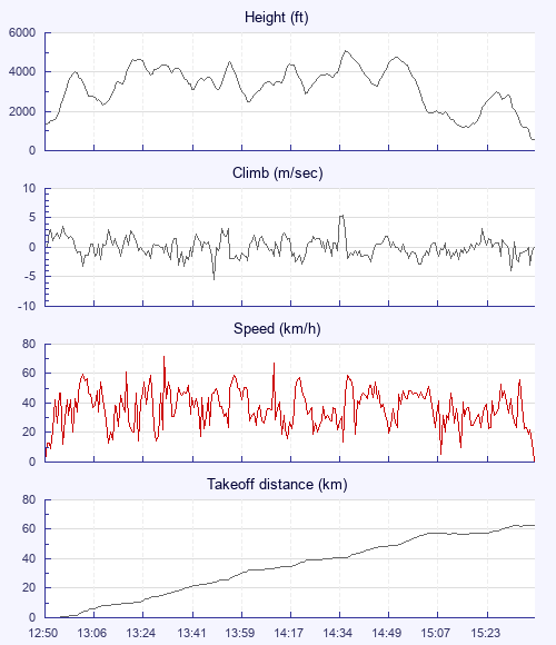
The first part of the flight, the lift was weak or broken and there was very little drift with the thermals.
I've not flown much this year so I basically just pimped off joe for the 1st part of the flight which was a massive help as I felt seriously rusty in my thermalling.
At some point before the Beacons, but not sure where, we did enjoy a nice strong core shared with a sail plane, the cloud was quite dark and there was another immediately ahead so to joe's disappointment I left on full bar before topping out.
Then not too far before the Beacons joe got a really sinky glide, I watched and decided it was safer to carry on thermalling to base. After seeing the unfortunate SW line joe took I aimed more South than him sticking with the clouds and heading towards the Beacons.
This all seemed to be going well as I came into the Beacons but everywhere was fairly shaded out. I had just enough height to pick up another shitty thermal above a bowl which was just a tad too high for joe to hook up with (he had to turn back to the flats to find something). It worked for me and I drifted over the mountains in weak lift and picked up another really weak thermal working it hard. Joe having pulled one out the bag again then joined me having found a nice low save in the flats. We worked it all the way to 4000' or so when boom, 2, then 3, then 5 m/s… Finally a really decent climb, I wasn't going to leave this one after all that work. A few whoops of excitement and I took it all the way past base and into the whispies of a newly forming cloud ending up surrounded by small fluffy clouds with most fantastic views of Wales.
At this point we were heading towards the wind turbines beyond 2 quarries. It was all pretty shaded but i aimed for the quarry to the east; on the way I found a weak climb and stuck with it until base. This was plenty of height to glide well above the turbines into the next valley. Joe thought he was going to land at this point so wished me luck as I flew on. I didn't find much in the next valley and then to my surprise there was Joe having crept in.
Joe landed on the rugby field right opposite the pub. I saw him pack up whilst I scratched around for 20 mins or so slowly losing what little height I had. I really wanted to make the coast so I stuck with it talking to myself whilst working with last bit of lift I could find. I thought about landing on the rugby field at least twice, but the sun had returned so surely it would start working. I was finally rewarded and climbed out of the valley but either lost the thermal or it just died before reaching base. I headed ssw aware of Cardiff airspace. Then I noticed my ground speed slow and the air go lifty but bumpy. This must be the sea breeze I've never flown in. Holy crap this is bumpy. At this point I had been in the air for ages, I was feeling cold and mentally drained after the fight to leave the last valley. Thinking back, I should have turned and headed west to ride the SB, but for some reason (even though it was an obvious sea breeze as I was now flying south but into a strong headwind) I continued SSW. WTF was I thinking?
Well that was not only a shit decision but I was now sinking like a brick in really really crappy air fighting to keep the glider open in a strong southerly as I dropped into the lee of a ridge. Not the best place to be. At the time I didn't want to fly to the other side of the valley as I thought the ridge would pop me back up and if it was string enough towards the wind turbines. Don't need that shit right, but in hindsight, it would probably have been smoother air.
I had a huge landing option open to me on the valley floor which was of a load of rugby fields. It was not so easy getting down though. Forward speed was not easy, the air was either lifty or sinky switching between the 2 every 2 seconds so it didn't feel like I was either going to land or climb out, I was stuck in crappy air not going forward, up or down. I figured that I'd flown well to the south of the convergence by now so time to pull the ears in and get on bar and get out of this air pronto. Not far from the ground I found myself going up (on bar and with ears in) and what also felt like slightly backwards towards the town. Anyway, I made it down and I was cold and mentally tired.
I realised I had not really eaten since about 7:30am on the drive up. I even had a good easy snack in my jacket pocket. I think if I had I eaten earlier in the flight when the going was easier I would have made better decisions as to direction when I hit the sea breeze and could have continued flying. At the very least I wouldn't have felt cold (I was properly dressed so it must have been food)
So, I take away from this flight:
1. It's good to leave early if you can, if the day has not got going yet you can always just take it slow to start with.
2. Fly a little faster when possible and I might have got further before being shaded out and also the sea breeze would have been further south.
3. When it's shaded out stay high, don't take unnecessary risks in terms of losing height.
4. Stick with it, keep scratching, a climb will come eventually.
5. Eat the easy access sugar laden breakfast bar I brought to keep my energy levels up.
6. Part 1 of the retrieve was masterful. However, For part 2, make sure everyone knows how to send their location and has a way of charging their phones. Needless to say, part 2 of the retrieve needed improvement.