


As it dawned on Monday plans for Tuesday began to surface. Having absolutely promised myself a hard weeks work; rasp and the excited speculation broke my resolve.
Jules had a plan to fly his enormous triangle from last year but adding a couple of k's on each leg to bring the record home and back to a hill! A brave second leg into rannoch moor I thought, but I planned to at least fly the first leg.
Pleasant walk up carn Dubh, carefully avoiding hundreds of frogs hopping through the heather, a smile as I remembered a story of a thrill seeking frog that once climbed into a comp wing, hopping out at 6000ft.
Brand new glider, in all its wrapping, a crispness unfelt for a few years… Some confidence that my well used wing no longer inspired. Thanks Paolo for the loan of the demo gin explorer.
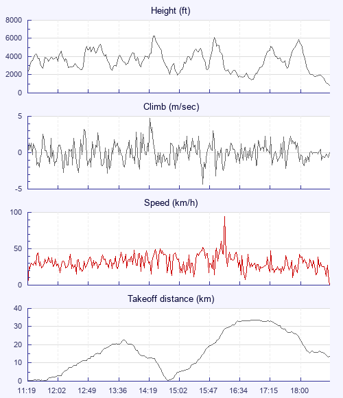
Occasional short lived cycles coming through, cumulus seemingly everywhere but here. At about 11 I launched to get a feel for the wing before things got going. And straight into a thermal. Up and away with Jules, Dave, Cathal and John.
Jules led out west along creag meagaidh, I followed much slower and soon lost him. After a mixture of ratty low climbs it got better to the west and I was at base at last with options. I scanned the sky for friends. Feeling a bit indecisive at end of the Megaidh range i pushed out towards a little wisp not wanting to go any deeper. Visual with friend: Big bird 500ft in front and below, cruising and gaining height, looking super stable, Follow that bird! I glide out and follow his line, he's circling now ahead and level with me. I head for his thermal, cost of entry- a sudden frontal and some s. I. V. A small price I thought as I followed this truly majestic white tailed sea eagle into the core and we shared a few turns before he left me; with an unflinching certainty of where he was going, he glided west to find jules. After a few more turns I followed the eagle west and and was delighted to see Jules now approaching, looking quite low from across the valley, he worked his way up and it looked like time to head back to takeoff.
Much easier getting back, big climb from the coires of megaidh which allowed a direct lifty line over high ground back to launch. A familiar weak thermal at the end of the ridge allowed a bimble onto the line of hills heading north east where I'd seen dave and jules climb out earlier. No gliders visible at this point but I imagined the others still pushing on somewhere in the distance.
The sky had improved at this point and I followed clouds to Kingussie where I spotted two gliders lowish approaching from the south. I cruised out to a cloud over the town expecting a lift, but didn't find it, so turned back to the terrain. By this point the gliders were together at base directly overhead; I was low and desperate to join them. It looked like game over as drifted low to scratch a hill north of Kincraig. I'd almost given up when I caught a funny drifty thermal, which lifted me through opposite directions of wind as I climbed to base. Having spent some time focused on my escape, I'd lost the two gliders which had now disappeared towards Aviemore.
Not having a radio I didn't know where anyone was… (must resolve). I checked my phone at the top of the climb… It was 5pm ish, scanning the messages on whatsapp- all had landed, and there was a post from jules saying that if I could get back from here it would be a record out and return… Decision made- back i go.
Gliding west in convergence now I think, easy lift and nice clouds, wisps forming around and below, slight headwind though making progress. A huge coloured disc of polar stratospheric cloud sits miraculous in the blue above me as I emerge from cloudbase. The last two climbs are strong and consistent and I start to believe I can make it. Good sky ahead and shifting goalpost now in sight! I follow a nice line to Newtonmore.
At Newtonmore I take a wrong turn (with hindsight). Leaving my outbound course i head southwest towards the road - away from the nice convergence line on the more retrieve complicated hills behind; and at 6:30pm I'm stuck soaring the smaller creag dubh, sun blocked by the convergence to the north, with the occasional light patch breaking through providing a flutter. A hopeful glide away from the hill behind two buzzards, and an optimistic search at the edge of a forest… Farm buildings ahead seem to be giving the seagulls something; but I'm too low to clear them, so landing checks and wheels down. Julian is there in seconds with him and John M having been following below. Thank you! Packed up to Aviemore where the mystery gliders crossed earlier were Bob and Stephen who'd flown 100k here from Tarmachan!