Xc Title
User:Guest
Cloudbase Paragliding advert
Robert Matthews  All flights  - Open Distance
SHPF League 2017
Flight type image
Turnpoint Flight on a Paraglider
Club
LLSC
Glider
Ozone Delta 2
Date
5th July 2017
Start
12:22
Finish
15:38
Duration
3hrs 15mins
Takeoff
Creag Meaghaidh
Landing
Near Slochd
Coords
Takeoff
56.95600, -4.53290
Start
56.95027, -4.53343
TP1
57.05208, -4.38748
TP2
57.03480, -4.28145
TP3
57.16942, -3.97062
Finish
57.28497, -3.93778
Landing
57.28062, -3.93698
Distance and Score
Total
51.90k
Score
51.9
Filename
Use full pilot name
Download
Validated
Yes
Flight map
Notes

This map gives an overview of the flight, using the turnpoints to plot the track.

Use the for a detailed map and flight track.

Duration 0:00   Takeoff Distance 0
Controls
To animate the flight: click a point on the track, use the slider, or click the Play button.
slider
slider
Speed
Speed
Slower
Faster
Track color
No data
Highlights
Track data
Time: No data
Height:
Climb:
Speed:
Interval:
Units
Height: metres
Climb: m/sec
Speed: km/h
Distance: km
chart
Notes

Climb and Speed averaged over 10 second intervals.

These values may be lower than those shown by a flight instrument, which has access to continuous raw data.

Metric units are used for all chart data, except for Height which is shown in feet.

Height   -   GPS data
Maximum Height
[14:45:55]
5341 ft
Lowest Save
[12:29:05]
2024 ft
Takeoff Height
[12:16:35]
2054 ft
Landing Height
[15:40:25]
1381 ft
Total Ascent 18671 ft
Height Gain
Above Takeoff 3287 ft
Maximum 3317 ft
Low Point
as Lowest Save
2024 ft
High Point
as Maximum Height
5341 ft
Units
Climb   -   Pressure data
Maximum Climb
[13:51:55]
3.6 m/s
Minimum Climb
[15:17:05]
-3.5 m/s
Units
Speed
Maximum Speed
[15:32:15]
63.0 km/h
Average Speed
around course
15.9 km/h
Average Speed
over track length
28.6 km/h
Units
Tracklog
Flight Duration 3hrs 23mins
Track Points 1224
Recording Interval 10 secs
Statistics Interval 10 secs
Track Length 97.2 km
Units
Flight instrument   -   reported as
SKYTRAXX V1.69 SN:3328377776
Notes

Climb and Speed averaged over 10 second intervals.

These values may be lower than those shown by a flight instrument, which has access to continuous raw data.

Average Speed around course is measured from Start to Finish points.

Track Length is the cumulative distance between track points from Takeoff to Landing.

You can change the default units displayed - see the Options page.

5 Star for Trip Advisor.

Two days of 5 star forecasts and not a blink of sun was had.

Stephen and I headed north to spend the time in the playground of a certain Mr Shepherd. We rendezvoused at Lagan under a decidedly heavy looking sky. Much coffee was consumed before we ventured to launch and proceeded to the landing field swiftly. Shower avoidance.

An evening of good food, wine and banter later, Wednesday dawned bright. A much more promising looking sky but with an awkward set of wind and thermal parameters from which to fashion a doable task. Ever resourceful Tony set a goal flight. Launch at Creag Meaghaidh, turn-points at Laggan and middle of nowhere then goal at Forres.

It's not a long walk to a launch but it is an energy sapping piece of terrain. Turns out also that Tony prefers tricky river crossings to bridges. It felt like we left the carpark as teenagers and arrived at launch as pensioners. The truth will out. Two pensioners and a part time worker go flying.

It's been a funny old year, the weather reality turns out to be quite unlike the forecast, once again. Cloud and a south westerly rather than southerly and sunny.

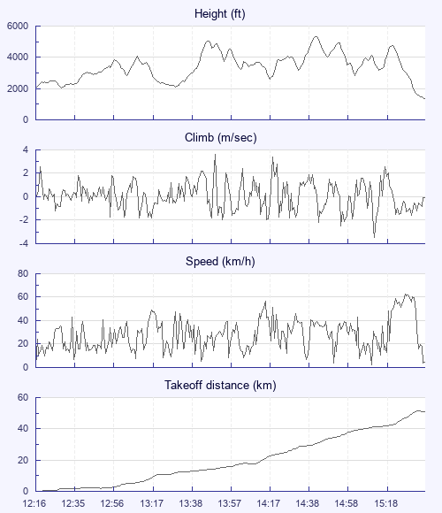
What unfolded was a very slow sunless scramble Spey-wise on a task that was very nearly done, with Tony and I falling short and Stephen making it all the way to Inverness. Another grand day out.

A grand two days in fact with our host. 5 star for the trip advisor, but only 3 stars for Rasp.

Is it not a ridiculous premise that brings us together for such fun. Defying Isaac with dental floss and plastic sheets. It is actually quite mind blowing.

Quote of the trip: -

Overheard as Stephen and I coffee'd at the Dalwhinnie truck stop. Three Muslim holidaymakers enquired if there were any pork products in the full Scottish breakfast.

"It's aw pork, it's aw pork, it's aw pork, it's whit it is". The proprietors mastery of customer care was somewhat exposed. The Scottish tourism industry has a way to go, it seems.

Best news of the trip: -

The awakening continues. Bren is now responding to stimulus.

Use this page to set various display Options. You can choose which units are used to display flight data, which map to show when the starts and which tab to show each time you view a flight.
Units settings

Metric units are used by default for the Statistics and XC Player pages, except for Height data which is shown in feet. You can choose your own custom settings here.

Height:
Speed:
Climb:
Distance:
  Use default
XC Player settings

When the XC Player starts, the track data is shown on the Hybrid map. You can choose a different map here.

Main Map:
  Use default
Tab settings

The first tab shown when you view a flight is the Flight Map. You can choose a different tab here.

First Tab:
  Use default
Notes

This page uses cookies to save your settings for future visits.

If you have disabled cookies for this site then any changes you make will not be saved.