Xc Title
User:Guest
Naviter advert
Harry Bloxham  All flights
National League 2018
Flight type image
Declared FAI Triangle on a Paraglider
Club
Avon
Glider
Ozone Enzo 3
Date
7th July 2018
Start
13:07
Finish
17:05
Duration
3hrs 57mins
Takeoff
Blorenge
Coords
Takeoff
51.80392, -3.04970
Start
51.81972, -3.02445
TP1
52.06000, -3.20305
TP2
52.02695, -2.64362
Finish
51.81972, -3.02445
Landing
51.80332, -3.04947
Distances and Score
Leg 1
29.42k
Leg 2
38.56k
Leg 3
34.90k
Distance
102.88k
Deductions
2.40k  (cylinders)
Total
100.48k
Multiplier
x 2.70
Score
271.3
Open Distance
Total
38.7k
Filename
Use full pilot name
Download
Validated
Yes
Flight map
Notes

This map gives an overview of the flight, using the turnpoints to plot the track.

Use the for a detailed map and flight track.

Duration 0:00   Takeoff Distance 0
Controls
To animate the flight: click a point on the track, use the slider, or click the Play button.
slider
slider
Speed
Speed
Slower
Faster
Track color
No data
Highlights
Track data
Time: No data
Height:
Climb:
Speed:
Interval:
Units
Height: metres
Climb: m/sec
Speed: km/h
Distance: km
chart
Notes

Climb and Speed averaged over 4 second intervals.

These values may be lower than those shown by a flight instrument, which has access to continuous raw data.

Red values indicate suspect data, because the tracklog contains invalid points.

Metric units are used for all chart data, except for Height which is shown in feet.

Height   -   GPS data
Maximum Height
[14:37:40]
5978 ft
Lowest Save
[15:59:43]
1381 ft
Takeoff Height
[12:41:59]
1722 ft
Landing Height
[17:14:32]
1719 ft
Total Ascent 39304 ft
Height Gain
Above Takeoff 4255 ft
Maximum 5043 ft
Low Point
[12:48:38]
935 ft
High Point
as Maximum Height
5978 ft
Units
Climb   -   GPS data
Maximum Climb
[13:56:11]
6.0 m/s
Minimum Climb
[15:28:02]
-6.5 m/s
Units
Speed
Maximum Speed
[14:40:28]
67.1 km/h
Average Speed
around course
25.3 km/h
Average Speed
over track length
40.5 km/h
Units
Tracklog
Flight Duration 4hrs 32mins
Track Points 12824
Recording Interval 1 secs
Statistics Interval 4 secs
Track Length 183.9 km
Invalid Positions
[< 1%]
1
Units
Flight instrument
Type Flyskyhy
Model 6.11
Firmware 6.11
Notes

Climb and Speed averaged over 4 second intervals.

These values may be lower than those shown by a flight instrument, which has access to continuous raw data.

Red values indicate suspect data, because the tracklog contains invalid points.

Average Speed around course is measured from Start to Finish points.

Track Length is the cumulative distance between track points from Takeoff to Landing.

You can change the default units displayed - see the Options page.

I was a bit too worried about bombing out from take off which meant all the others who were trying the same route had already started the first leg while I was still sat on the hill. When I did eventually launch, I didn't find my first climb until I was 900 foot below take off! Luckily there were quite a few others who launched at the same time (or slightly before with a bit of encouragement from me) which helped, I'd have landed before it had even begun if it wasn't for them showing me the climbs!

That left me on my own for almost the whole flight! There was lots of sink heading towards the Sugar Loaf but after that the first leg through the mountains was relatively straight forward. I knew I had to fly fast to make it around the course in time and I thought I was making good time. Until I saw Ken, who launched at the same time as me, pass over my head in orbit on his EN-B as I was getting a climb fairly low on the hills behind the Sugar Loaf.

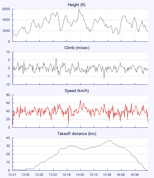
Things slowed down in the flats before TP1 but a 6m/s climb near Hay-on-Wye up to 6000ft gave me a comfortable glide into the English flats, just before things started getting tricky. Despite it being a very light wind day, all of the thermals felt very broken and I didn't manage to get back to cloudbase for the rest of the day.

I drifted in and out of TP2 barely able to maintain 2000ft, any bit of lift I could find was very short-lived. I was low and the terrain didn't offer anything obvious to aim for, I was starting to get a worried. I caught a bird in the corner of my eye, upwind but just within reach, it had to work and thankfully it did! It took me to around 5000ft but it was looking very blue towards goal. Garway and the Skirrid were both on course line but Garway was a marginal glide in a cross wind from where I was and I'd need a good climb once I got there to connect with the Skirrid. A couple of small bubbles stretched my glide to reach Garway where I topped up as much as I could then headed off towards Luke and Lawrie who I could now see thermalling low near the Skirrid.

I arrived 100ft below them and just above the summit but still about 2km from the hill. They were barely going up, I wasn't, a few more turns and I'd be picking a landing field so I dived for the into wind north face. 3m/s of sink put me level with the very base of the north face, still too far away to reach it, I thought it was all over. But nature rescued me again! I spotted another bird, this time it wasn't circling, just flying straight, but it wasn't going down, it was my only chance. 0 turned into 0.5 into 1 into 2m/s. Luke and Lawrie soon joined me and a few minutes later we were top landing back on the Blorenge to retrieve our cars!

I had added 10k on to my PB triangle distance two days in a row and I think this one was a British speed record for 100k! Not a bad weekend!

Use this page to set various display Options. You can choose which units are used to display flight data, which map to show when the starts and which tab to show each time you view a flight.
Units settings

Metric units are used by default for the Statistics and XC Player pages, except for Height data which is shown in feet. You can choose your own custom settings here.

Height:
Speed:
Climb:
Distance:
  Use default
XC Player settings

When the XC Player starts, the track data is shown on the Hybrid map. You can choose a different map here.

Main Map:
  Use default
Tab settings

The first tab shown when you view a flight is the Flight Map. You can choose a different tab here.

First Tab:
  Use default
Notes

This page uses cookies to save your settings for future visits.

If you have disabled cookies for this site then any changes you make will not be saved.