Xc Title
User:Guest
Cloudbase Paragliding advert
Andrew Craig  All flights
National League 2018
Flight type image
Turnpoint Flight on a Paraglider
Club
Southern
Glider
Nova Phantom
Date
14th July 2018
Start
12:41
Finish
13:28
Duration
46mins
Takeoff
Milk Hill White Horse
Landing
Ogbourne Saint George
Coords
Takeoff
51.37207, -1.85687
Start
51.37148, -1.85668
TP1
51.42405, -1.83055
TP2
51.41470, -1.79177
TP3
51.41992, -1.76055
Finish
51.46713, -1.71330
Landing
51.46660, -1.71373
Distances and Score
Leg 1
6.13k
Leg 2
2.89k
Leg 3
2.25k
Leg 4
6.20k
Total
17.47k
Score
17.5
Open Distance
Total
14.6k
Filename
Use full pilot name
Download
Validated
Yes
Flight map
Notes

This map gives an overview of the flight, using the turnpoints to plot the track.

Use the for a detailed map and flight track.

Duration 0:00   Takeoff Distance 0
Controls
To animate the flight: click a point on the track, use the slider, or click the Play button.
slider
slider
Speed
Speed
Slower
Faster
Track color
No data
Highlights
Track data
Time: No data
Height:
Climb:
Speed:
Interval:
Units
Height: metres
Climb: m/sec
Speed: km/h
Distance: km
chart
Notes

Climb and Speed averaged over 4 second intervals.

These values may be lower than those shown by a flight instrument, which has access to continuous raw data.

Metric units are used for all chart data, except for Height which is shown in feet.

Height   -   GPS data
Maximum Height
[12:56:31]
4265 ft
Lowest Save
[13:13:53]
1427 ft
Takeoff Height
[12:41:31]
853 ft
Landing Height
[13:28:56]
505 ft
Total Ascent 6470 ft
Height Gain
Above Takeoff 3412 ft
Units
Climb   -   Pressure data
Maximum Climb
[13:20:19]
4.8 m/s
Minimum Climb
[13:13:19]
-4.8 m/s
Units
Speed
Maximum Speed
[12:58:43]
67.5 km/h
Average Speed
around course
22.4 km/h
Average Speed
over track length
35.2 km/h
Units
Tracklog
Flight Duration 47mins
Track Points 2846
Recording Interval 1 secs
Statistics Interval 4 secs
Track Length 27.8 km
Units
Flight instrument
Type Syride
Model Sys'Nav
Firmware 3.27
Notes

Climb and Speed averaged over 4 second intervals.

These values may be lower than those shown by a flight instrument, which has access to continuous raw data.

Average Speed around course is measured from Start to Finish points.

Track Length is the cumulative distance between track points from Takeoff to Landing.

You can change the default units displayed - see the Options page.

There had been a plethora of Notams all over the area, but most had been cancelled. That still left the transit of the Red Arrows, from Fairfor to Goodwood and back, at a not precisely specified time. And then there was the World Cup third-place play-off, and the men's singles final at Wimbledon…

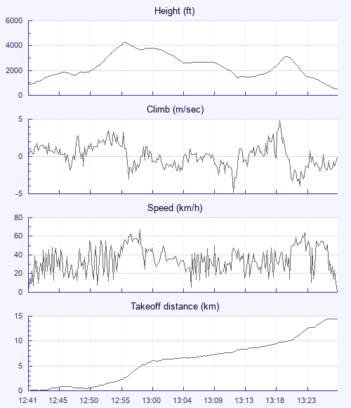
So perhaps a short flight was a good thing. I got my wing out in the bowl, but when Kirsty landed and said it was horrible, I followed Steve Newcombe's example and walked around to the White Horse spur, arriving as a gaggle climbed out.

For the next hour or so, no one got high, and I slope-landed several times. But then a couple pushed boldly out front and went up, prompting a large bunch of us to pimp off them. My first climb seemed to fizzle out over the bowl, and rather than charge blindly downwind I calculated that I might just be able to get back to join a gaggle still climbing over the White Horse launch. I made it (Phantoms are good)

But I reached base later than the rest, so set off on my own, chasing Steve. I joined him in a zero, and then glided even lower. As we wandered around looking for a climb, I found one, while Steve bombed. But I lost mine well short of base, and my next glide was to the ground at Ogbourne St George. A local resident came to welcome me and point out the exit from the field - he said the farmer was grumpy, and would be so even if I'd landed and handed him a gold bar, so I didn't hang around to meet him.

A quick drink in the Inn With The Well, and home in time to watch the second half of the football. Nice.

Use this page to set various display Options. You can choose which units are used to display flight data, which map to show when the starts and which tab to show each time you view a flight.
Units settings

Metric units are used by default for the Statistics and XC Player pages, except for Height data which is shown in feet. You can choose your own custom settings here.

Height:
Speed:
Climb:
Distance:
  Use default
XC Player settings

When the XC Player starts, the track data is shown on the Hybrid map. You can choose a different map here.

Main Map:
  Use default
Tab settings

The first tab shown when you view a flight is the Flight Map. You can choose a different tab here.

First Tab:
  Use default
Notes

This page uses cookies to save your settings for future visits.

If you have disabled cookies for this site then any changes you make will not be saved.