Xc Title
User:Guest
Cloudbase Paragliding advert
Dave Thomas  All flights
Dunstable League 2018
Flight type image
Turnpoint Flight on a Paraglider
Club
Long Mynd
Glider
Advance Sigma 10
Date
25th July 2018
Start
13:25
Finish
17:56
Duration
4hrs 30mins
Takeoff
Worcestershire Beacon
Landing
Nr How Caple
Coords
Takeoff
52.10450, -2.33988
Start
52.10733, -2.33537
TP1
52.21220, -2.65293
TP2
51.99273, -2.64887
TP3
52.00035, -2.58663
Finish
51.97003, -2.55645
Landing
51.97017, -2.55632
Distances and Score
Leg 1
24.67k
Leg 2
24.42k
Leg 3
4.36k
Leg 4
3.96k
Total
57.41k
Score
57.4
Open Distance
Total
27.7k
Filename
Use full pilot name
Download
Validated
Yes
Flight map
Notes

This map gives an overview of the flight, using the turnpoints to plot the track.

Use the for a detailed map and flight track.

Duration 0:00   Takeoff Distance 0
Controls
To animate the flight: click a point on the track, use the slider, or click the Play button.
slider
slider
Speed
Speed
Slower
Faster
Track color
No data
Highlights
Track data
Time: No data
Height:
Climb:
Speed:
Interval:
Units
Height: metres
Climb: m/sec
Speed: km/h
Distance: km
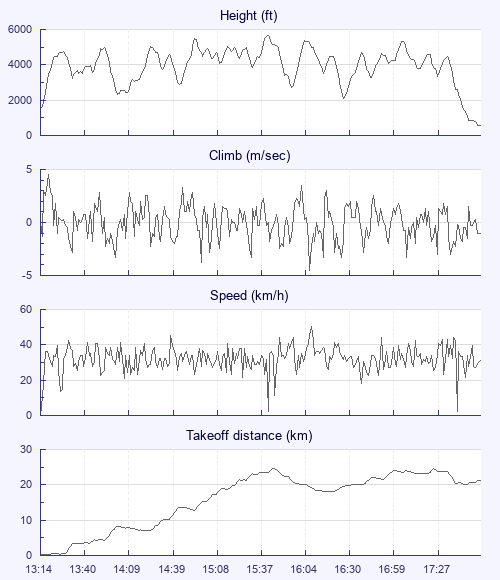
chart
Notes

Climb and Speed averaged over 4 second intervals.

These values may be lower than those shown by a flight instrument, which has access to continuous raw data.

Metric units are used for all chart data, except for Height which is shown in feet.

Height   -   GPS data
Maximum Height
[15:43:41]
5636 ft
Lowest Save
[16:30:01]
2119 ft
Takeoff Height
[13:14:02]
1539 ft
Landing Height
[17:56:05]
561 ft
Total Ascent 34144 ft
Height Gain
Above Takeoff 4098 ft
Maximum 4108 ft
Low Point
[13:14:03]
1529 ft
High Point
as Maximum Height
5636 ft
Units
Climb   -   GPS data
Maximum Climb
[13:19:22]
4.5 m/s
Minimum Climb
[16:08:38]
-4.5 m/s
Units
Speed
Maximum Speed
[16:09:26]
50.4 km/h
Average Speed
around course
12.8 km/h
Average Speed
over track length
32.2 km/h
Units
Tracklog
Flight Duration 4hrs 42mins
Track Points 16924
Recording Interval 1 secs
Statistics Interval 4 secs
Track Length 151.4 km
Units
Flight instrument   -   reported as
Nexus 7, SW6.0.1
Notes

Climb and Speed averaged over 4 second intervals.

These values may be lower than those shown by a flight instrument, which has access to continuous raw data.

Average Speed around course is measured from Start to Finish points.

Track Length is the cumulative distance between track points from Takeoff to Landing.

You can change the default units displayed - see the Options page.

I was up for it today and in a postive mood, unlike the day before when too tired to get the wing out of the bag. Sleep really is the most important pre flight routine.

Anyway, tried and had a slope landing but was still itching and once someone else launched and stayed up in an obviuos thermal lift i was off and led the climb straight out for 6 of us. Lovely. I was then first off on the glide to the first of the equilateral triangle 75 k tpts for goal that most had declared. Howver i struggled as usual and was really slow, after an hour only 7k from launch. Had a nice bit of help ftrom Bryan, but I think he got bored with my slow progress vertically and left me behind. Most of the rest of the flight was on my own but always with other gliders in front or behind me in the distance. Pretty well blue almost the whole time, any clouds if attempted faded away before i arrived. Caught up with a couple of gliders near Hereford and tagged along which was really nice. Had to make a decision heading for second turnpoint, and chose to go for lift above big wheat field off track, the other glidr went straight for tpt, got it then came in under me but very low and never quite made it back up.

Meanwhile i was patiently waiting to see them start a goid climb so that i could nip off 2k to bag tpt and return to rejoin the lift. Had to do it anyway which turned out ok but then made the one big mistake of the day. I had a choice to either go straight home via Much Marcle ridge and a lot of greenery, or retrace my route back to Hereford, I chose the former and had sink bad nough to mean i was unlikely to get over the ridge and onto the big wheat fields. I turned off to try some small fields and the last one at less than 300ft nearly got me up but I didnt core it well enough and the now moderate north wind drifted me over woodland so gave up and popped in a field.

Failing in the task, taught me lots of lessons and the social retrieve nearly made up for missing an extra 140 tesco points.

Use this page to set various display Options. You can choose which units are used to display flight data, which map to show when the starts and which tab to show each time you view a flight.
Units settings

Metric units are used by default for the Statistics and XC Player pages, except for Height data which is shown in feet. You can choose your own custom settings here.

Height:
Speed:
Climb:
Distance:
  Use default
XC Player settings

When the XC Player starts, the track data is shown on the Hybrid map. You can choose a different map here.

Main Map:
  Use default
Tab settings

The first tab shown when you view a flight is the Flight Map. You can choose a different tab here.

First Tab:
  Use default
Notes

This page uses cookies to save your settings for future visits.

If you have disabled cookies for this site then any changes you make will not be saved.