Xc Title
User:Guest
Cloudbase Paragliding advert
Viv Fouracre  All flights
National League 2018
Flight type image
Turnpoint Flight on a Paraglider
Club
SE Wales
Glider
Swing Nyos RS
Date
11th August 2018
Start
11:35
Finish
12:44
Duration
1hr 8mins
Takeoff
Eyam
Landing
Brampton Bierlow
Coords
Takeoff
53.29627, -1.69583
Start
53.29627, -1.69583
TP1
53.29453, -1.69227
TP2
53.29552, -1.69803
TP3
53.49868, -1.38660
Finish
53.49382, -1.38362
Landing
53.49373, -1.38428
Distances and Score
Leg 1
0.31k
Leg 2
0.40k
Leg 3
30.67k
Leg 4
0.58k
Total
31.96k
Score
32.0
Open Distance
Total
30.7k
Filename
Use full pilot name
Download
Validated
Yes
Flight map
Notes

This map gives an overview of the flight, using the turnpoints to plot the track.

Use the for a detailed map and flight track.

Duration 0:00   Takeoff Distance 0
Controls
To animate the flight: click a point on the track, use the slider, or click the Play button.
slider
slider
Speed
Speed
Slower
Faster
Track color
No data
Highlights
Track data
Time: No data
Height:
Climb:
Speed:
Interval:
Units
Height: metres
Climb: m/sec
Speed: km/h
Distance: km
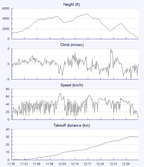
chart
Notes

Climb and Speed averaged over 4 second intervals.

These values may be lower than those shown by a flight instrument, which has access to continuous raw data.

Metric units are used for all chart data, except for Height which is shown in feet.

Height   -   GPS data
Maximum Height
[12:17:05]
5030 ft
Lowest Save
[12:30:38]
1539 ft
Takeoff Height
[11:35:18]
1270 ft
Landing Height
[12:45:18]
240 ft
Total Ascent 8245 ft
Height Gain
Above Takeoff 3760 ft
Maximum 3783 ft
Low Point
[11:36:02]
1247 ft
High Point
as Maximum Height
5030 ft
Units
Climb   -   Pressure data
Maximum Climb
[12:30:50]
5.0 m/s
Minimum Climb
[12:41:46]
-5.0 m/s
Units
Speed
Maximum Speed
[12:02:30]
69.3 km/h
Average Speed
around course
27.8 km/h
Average Speed
over track length
38.1 km/h
Units
Tracklog
Flight Duration 1hr 10mins
Track Points 4201
Recording Interval 1 secs
Statistics Interval 4 secs
Track Length 44.5 km
Units
Flight instrument
Type Oudie 3
Model Not Set
Firmware 7.40.004
Notes

Climb and Speed averaged over 4 second intervals.

These values may be lower than those shown by a flight instrument, which has access to continuous raw data.

Average Speed around course is measured from Start to Finish points.

Track Length is the cumulative distance between track points from Takeoff to Landing.

You can change the default units displayed - see the Options page.

Final task of the 2018 BPCup and we are on Eyam Edge, with it's deserved reputation as a tricksy site! A downwind task of 29k to goal just before the airspace, not a long task but tricky as conditions were set to deteriorate on launch with the wind forecast to really pick up.

My 3rd attempt, after two fortunate top landings, several went down, saw me climbing away in a mixed gaggle of BPCup and local pilots. Up and away to cloudbase we went, away over Stanage and on NW of Sheffield. Climbs were mixed, some lovely and nice to work, others horrible with nasty sharp edges. I was working a really horrible, knarly thing, looked down and realised I didn't need to as my Oudie was telling me goal was within reach, hooray.

I heard others on the radio say they were going to carry on and the sky ahead certainly looked good enough, but it was our last day with prize giving to organise and I needed to get back so my trip to Scarborough will have to wait for another day.

I had a great day out and a super easy retrieve with 3 other BPCup guys and the XCL's very own Mr J Stevenson - what's not to like?

Use this page to set various display Options. You can choose which units are used to display flight data, which map to show when the starts and which tab to show each time you view a flight.
Units settings

Metric units are used by default for the Statistics and XC Player pages, except for Height data which is shown in feet. You can choose your own custom settings here.

Height:
Speed:
Climb:
Distance:
  Use default
XC Player settings

When the XC Player starts, the track data is shown on the Hybrid map. You can choose a different map here.

Main Map:
  Use default
Tab settings

The first tab shown when you view a flight is the Flight Map. You can choose a different tab here.

First Tab:
  Use default
Notes

This page uses cookies to save your settings for future visits.

If you have disabled cookies for this site then any changes you make will not be saved.