Xc Title
User:Guest
UK Airsports advert
Frazer Wilson  All flights
Dunstable League 2019
Flight type image
FAI Triangle on a Paraglider
Club
Sky Surfing
Glider
Date
6th July 2019
Start
14:03
Finish
16:19
Duration
2hrs 16mins
Takeoff
Harting Down
Coords
Takeoff
50.95965, -0.88443
Start
50.95927, -0.88277
TP1
50.94132, -0.95552
TP2
51.03448, -0.92747
TP3
50.99795, -0.82048
Finish
50.95923, -0.88277
Landing
50.95657, -0.87762
Distances and Score
Leg 1
11.39k
Leg 2
10.55k
Leg 3
8.54k
Distance
30.48k
Deductions
0.00k  (circuit gap 4m)
Total
30.48k
Multiplier
x 2.00
Score
61.0
Open Distance
Total
13.6k
Filename
Use full pilot name
Download
Validated
Yes
Flight map
Notes

This map gives an overview of the flight, using the turnpoints to plot the track.

Use the for a detailed map and flight track.

Duration 0:00   Takeoff Distance 0
Controls
To animate the flight: click a point on the track, use the slider, or click the Play button.
slider
slider
Speed
Speed
Slower
Faster
Track color
No data
Highlights
Track data
Time: No data
Height:
Climb:
Speed:
Interval:
Units
Height: metres
Climb: m/sec
Speed: km/h
Distance: km
chart
Notes

Climb and Speed averaged over 4 second intervals.

These values may be lower than those shown by a flight instrument, which has access to continuous raw data.

Red values indicate suspect data, because the tracklog contains invalid points.

Metric units are used for all chart data, except for Height which is shown in feet.

Height   -   GPS data
Maximum Height
[15:25:14]
5276 ft
Lowest Save
[15:41:47]
1460 ft
Takeoff Height
[14:03:08]
2113 ft
Landing Height
[16:23:18]
617 ft
Total Ascent 17516 ft
Height Gain
Above Takeoff 3163 ft
Maximum 3327 ft
Low Point
[14:16:57]
1949 ft
High Point
as Maximum Height
5276 ft
Units
Climb   -   Pressure data
Maximum Climb
[14:03:10]
5.5 m/s
Minimum Climb
[15:25:31]
-5.0 m/s
Units
Speed
Maximum Speed
[15:25:31]
77.4 km/h
Average Speed
around course
13.4 km/h
Average Speed
over track length
34.1 km/h
Units
Tracklog
Flight Duration 2hrs 20mins
Track Points 5233
Recording Interval 2 secs
Statistics Interval 4 secs
Track Length 79.7 km
Invalid Positions
[< 1%]
1
Units
Flight instrument
Type Flyskyhy
Model 6.9
Firmware 6.9
Notes

Climb and Speed averaged over 4 second intervals.

These values may be lower than those shown by a flight instrument, which has access to continuous raw data.

Red values indicate suspect data, because the tracklog contains invalid points.

Average Speed around course is measured from Start to Finish points.

Track Length is the cumulative distance between track points from Takeoff to Landing.

You can change the default units displayed - see the Options page.

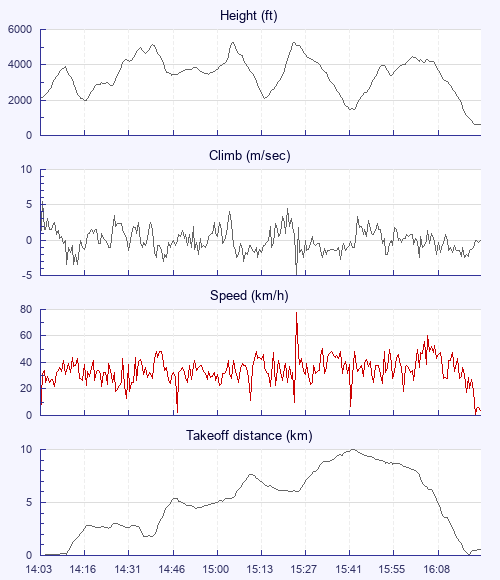
The track looks "odd", because it was odd: driven by the fact that the clouds developed quite quickly, then spread out and took quite a while to fizzle away, and didn't move much - due to zilch wind; that, plus patches of top cover meant there were large areas of ground in shade for really long periods - so although I intended to do a triangle, I had to navigate a torturous path, hoping to string together the next two or three sunny bits I thought I could reach with half a glide. The final Southward return leg from Liss turned a bit silly - I thought my (sunny-patch) luck had run out, as it was clagged out all the way home, but it was the lifitiest bit of the flight, I was either on full bar or doing a series of short spirals (5-6 times) to keep under the 4,500 ceiling.

I am very grateful for some outside assistance, too:

The first was the ever-helpful Keiron Doick, who scientifically timed the thermal gusts and lulls, as there was zero meteo wind on the hill. We decided it was in regular 10 min cycles, and the previous 2 had had birds climb out nicely beyond the tree line. So after the 4th abrupt lull, I counted 4 more minutes, and then popped off into the void (nil wind), connecting almost immediately with very scrappy, moderately buoyant lift; 2-3 mins later I was able to push out into a building line of lift - so 10 mins it was and the theory worked a treat!

The second was also early on, when a white-winged microlight approached me within ≈1km, waggled his wings when head on, then turned away to the West and proceded to thermal upwards for a couple of turns with remarkably low airspeed - curious, thinks I… Then it dawned on me, it might just be Jan Henslow marking a thermal for me - which is exactly who & what it proved to be. I headed over, he pulled out of the climb and I shouted, waved and blew kisses as he gave me a fly by once I was established in the climb.

Greater love hath no pilot than this, than he lay down his own flight for his friend's.

No retrieve needed, I could get used to these Toblerones: )

Use this page to set various display Options. You can choose which units are used to display flight data, which map to show when the starts and which tab to show each time you view a flight.
Units settings

Metric units are used by default for the Statistics and XC Player pages, except for Height data which is shown in feet. You can choose your own custom settings here.

Height:
Speed:
Climb:
Distance:
  Use default
XC Player settings

When the XC Player starts, the track data is shown on the Hybrid map. You can choose a different map here.

Main Map:
  Use default
Tab settings

The first tab shown when you view a flight is the Flight Map. You can choose a different tab here.

First Tab:
  Use default
Notes

This page uses cookies to save your settings for future visits.

If you have disabled cookies for this site then any changes you make will not be saved.