Xc Title
User:Guest
Cloudbase Paragliding advert
Charles Norwood  All flights
National League 2010
Flight type image
Tow-launch Turnpoint Flight on a Paraglider
Club
XClent
Glider
Nova Triton
Date
3rd July 2010
Start
12:17
Finish
17:56
Duration
5hrs 39mins
Takeoff
XClent Roel Gate
Landing
Mildenhall
Coords
Takeoff
51.91755, -1.92362
Start
51.91658, -1.92883
TP1
52.11600, -1.31967
TP2
52.08495, -1.28275
TP3
52.33188, 0.27083
Finish
52.42883, 0.42147
Landing
52.42692, 0.41872
Distances and Score
Leg 1
47.34k
Leg 2
4.28k
Leg 3
109.70k
Leg 4
14.89k
Total
176.21k
Score
176.2
Open Distance
Total
170.7k
Filename
Use full pilot name
Download
Validated
Yes
Flight map
Notes

This map gives an overview of the flight, using the turnpoints to plot the track.

Use the for a detailed map and flight track.

Duration 0:00   Takeoff Distance 0
Controls
To animate the flight: click a point on the track, use the slider, or click the Play button.
slider
slider
Speed
Speed
Slower
Faster
Track color
No data
Highlights
Track data
Time: No data
Height:
Climb:
Speed:
Interval:
Units
Height: metres
Climb: m/sec
Speed: km/h
Distance: km
chart
Notes

Climb and Speed averaged over 4 second intervals.

These values may be lower than those shown by a flight instrument, which has access to continuous raw data.

Red values indicate suspect data, because the tracklog contains invalid points.

Metric units are used for all chart data, except for Height which is shown in feet.

Height   -   GPS data
Maximum Height
[17:19:51]
6624 ft
Lowest Save
[17:38:05]
1211 ft
Takeoff Height
[12:16:15]
978 ft
Landing Height
[17:57:31]
43 ft
Total Ascent 46398 ft
Height Gain
Above Takeoff 5646 ft
Units
Climb   -   GPS data
Maximum Climb
[17:12:40]
5.8 m/s
Minimum Climb
[13:55:23]
-4.3 m/s
Units
Speed
Maximum Speed
[15:53:23]
72.9 km/h
Average Speed
around course
31.2 km/h
Average Speed
over track length
42.9 km/h
Units
Tracklog
Flight Duration 5hrs 41mins
Track Points 20477
Recording Interval 1 secs
Statistics Interval 4 secs
Track Length 243.8 km
Invalid Positions
[< 1%]
23
Units
Flight instrument   -   reported as
XC Trainer V2.4-05, S/N 4080
Notes

Climb and Speed averaged over 4 second intervals.

These values may be lower than those shown by a flight instrument, which has access to continuous raw data.

Red values indicate suspect data, because the tracklog contains invalid points.

Average Speed around course is measured from Start to Finish points.

Track Length is the cumulative distance between track points from Takeoff to Landing.

You can change the default units displayed - see the Options page.

On the train making my way home after nearly six hours in the air… Tired and sunburnt having forgotten the cream again.

It started on Tuesday when Rich said Saturday looks record breaking, every one else thought it might be too windy, the day started ok with wind but not too much, not sure where to go in this Westerly, Frocester Rybury or winching, Rich called early and was aleady en-route to Edgehill and in a traffic jam, Wayne said Frocester was under loads of cloud so it was off to the winch field.

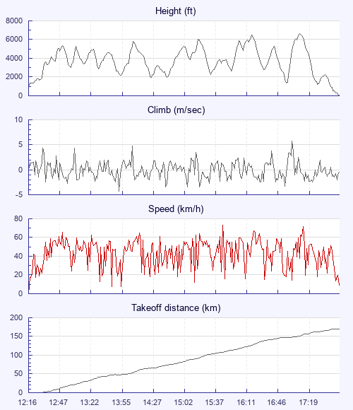
Away third tow with Mark already on his way down wind, slow climb out and Wayne marked the early lift, soon I'm alone as Wayne heads off impatiently, I dont have enough height yet and have to slow down to get to base which is about 4.8k at midday, the drift is quite strong, westerly between 15 and 24 km, before long Moreton in Marsh arrives with a detour to change cloud streets then Edgehill comes and goes, no sign of Rich, he has long gone by then, then over the gliding field and past the village of Ratley where I grew up, getting a bit low but not minding, as the views of my childhood pass beneath, the day is really looking epic now with base rising to 6+k and cloud streets stretch to the end of the world, sailplanes filling the air like confetti, in one cloud I get mobbed by about 8 of them, then they disappear like magic leaving me alone and relieved.

Airbox shouts warnings of 5.5k airspace to the north of me, I cross the M40 and glide on to pass north of Silverstone. I keep looking for Wayne and Mark but as I am usually the slowest I expect to get left behind. Gray should have caught me by now, pressing on its time for lunch with a quick Muesli bar and energy drink hastily forced down at the top of a thermal, trying not to drop anything on the unsuspecting motorists below.

Base is now even higher with full bar exhileration through the wispies - flying doesnt get better than this, get to the end of the street and look for the next one, passing over a drag strip below, two monster motors are fighting it out, then another twisty race track and i can hear the screeching tyres, Grafham water appears in the distance in shade with a windy surface, more sail planes are stacked up all the way down to the ground, I am mid-division and some of them are getting very intimate, the world and his glider are in the air today, still they have marked the lift and tempted me to over ambitious glides, in return they get to look at the funny man in a canoe at cloudbase, its perfect symbiosis.

Airspace blocks my way, and I fight the map in the breeze to try to work out which way to go, north or south by Newmarket, catch another cloud and head north, wrong move and i have to work too hard to avoid airspace, the canals and irigation drainage ditches of the fens are amazing from height, last glide out the now as it six pm, the altimeter reads below sea level when i land.

4 trains a taxi and two car rides later its home by midnight…

Use this page to set various display Options. You can choose which units are used to display flight data, which map to show when the starts and which tab to show each time you view a flight.
Units settings

Metric units are used by default for the Statistics and XC Player pages, except for Height data which is shown in feet. You can choose your own custom settings here.

Height:
Speed:
Climb:
Distance:
  Use default
XC Player settings

When the XC Player starts, the track data is shown on the Hybrid map. You can choose a different map here.

Main Map:
  Use default
Tab settings

The first tab shown when you view a flight is the Flight Map. You can choose a different tab here.

First Tab:
  Use default
Notes

This page uses cookies to save your settings for future visits.

If you have disabled cookies for this site then any changes you make will not be saved.