Xc Title
User:Guest
Naviter advert
Hugh Miller  All flights
National League 2014
Flight type image
Turnpoint Flight on a Paraglider
Club
Southern
Glider
Ozone Mantra M6
Date
27th July 2014
Start
12:46
Finish
18:35
Duration
5hrs 48mins
Takeoff
Bradwell
Landing
Nr Thetford
Coords
Takeoff
53.32097, -1.73017
Start
53.32487, -1.73132
TP1
53.18172, -0.94565
TP2
53.14487, -0.91522
TP3
53.06620, -0.49483
Finish
52.43060, 0.74242
Landing
52.43085, 0.74145
Distances and Score
Leg 1
54.81k
Leg 2
4.58k
Leg 3
29.48k
Leg 4
109.46k
Total
198.33k
Score
198.3
Open Distance
Total
194.0k
Filename
Use full pilot name
Download
Validated
Yes
Flight map
Notes

This map gives an overview of the flight, using the turnpoints to plot the track.

Use the for a detailed map and flight track.

Duration 0:00   Takeoff Distance 0
Controls
To animate the flight: click a point on the track, use the slider, or click the Play button.
slider
slider
Speed
Speed
Slower
Faster
Track color
No data
Highlights
Track data
Time: No data
Height:
Climb:
Speed:
Interval:
Units
Height: metres
Climb: m/sec
Speed: km/h
Distance: km
chart
Notes

Climb and Speed averaged over 10 second intervals.

These values may be lower than those shown by a flight instrument, which has access to continuous raw data.

Metric units are used for all chart data, except for Height which is shown in feet.

Height   -   GPS data
Maximum Height
[17:53:11]
6896 ft
Lowest Save
[17:24:00]
909 ft
Takeoff Height
[12:45:31]
1188 ft
Landing Height
[18:35:52]
167 ft
Total Ascent 39249 ft
Height Gain
Above Takeoff 5709 ft
Maximum 5988 ft
Low Point
as Lowest Save
909 ft
High Point
as Maximum Height
6896 ft
Units
Climb   -   Pressure data
Maximum Climb
[15:28:44]
4.0 m/s
Minimum Climb
[17:14:40]
-3.3 m/s
Units
Speed
Maximum Speed
[13:09:01]
68.8 km/h
Average Speed
around course
34.1 km/h
Average Speed
over track length
39.0 km/h
Units
Tracklog
Flight Duration 5hrs 50mins
Track Points 2102
Recording Interval 10 secs
Statistics Interval 10 secs
Track Length 227.7 km
Units
Flight instrument   -   reported as
Flymaster F1, V1.22, S/N 141
Notes

Climb and Speed averaged over 10 second intervals.

These values may be lower than those shown by a flight instrument, which has access to continuous raw data.

Average Speed around course is measured from Start to Finish points.

Track Length is the cumulative distance between track points from Takeoff to Landing.

You can change the default units displayed - see the Options page.

I was in Sheffield visiting my brother and family and base started to lift so he gave me a lift out to Bradwell. It wasn't very inspiring but Rasp looked great beyond the peaks. Took off in a lull (well, waited for HH Tsai to launch first, I'm a coward) and used some of the cloud suck to carry me up and out of the peaks, then took a long glide to get lowish over Chesterfield, and had to sit it out in weak zeros for a while waiting for the 8/8ths overcast to break up.

50 ks on it was a different story, the stratus broke up, the sun hit the ground and there were strong climbs all the way. It felt just like a cold front had just gone through, really unstable air and 'marge simpson' clouds which looked a bit too big, but even right under the darkest bases were totally managable.

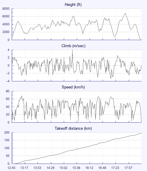
It was amazing flying right past the Wash - it looked like the Amazon delta, not that I've been there - and it felt nuts that I was seeing it, having flown over the Severn at the other end of the country a few weeks back. Base rose to about 6200 ft and near the end I climbed up the side of a cloud for some extra safety for the final push.

I'd declared a 195 goal so had to crosswind quite hard to get near it. The final glide was a sweat - I set off 13 km and 4000 ft, and hit surprisingly strong sink. Maths was never my strong point and I had no glide calculators set up, but I made it with 100 ft.

To prove maths isn't my strong point I'd also ballsed up the start cylinder. When you declare a flight you have to give a start lat/long and a finish. My eventual track was 200 m wide of my start cylinder - I just hadn't zoomed in properly on Bradwell on XCPlanner when planning the flight. So, that cost me the valuable 'multiplier' that gives declared flights such big points in the league. When I realised I wondered if I should be annoyed but it was such an amazing day out, I couldn't really be. The bonus was I'd left my car at Sharpenhoe from Thursday's flight so that was on the way home making for a fairly quick trip back.

Use this page to set various display Options. You can choose which units are used to display flight data, which map to show when the starts and which tab to show each time you view a flight.
Units settings

Metric units are used by default for the Statistics and XC Player pages, except for Height data which is shown in feet. You can choose your own custom settings here.

Height:
Speed:
Climb:
Distance:
  Use default
XC Player settings

When the XC Player starts, the track data is shown on the Hybrid map. You can choose a different map here.

Main Map:
  Use default
Tab settings

The first tab shown when you view a flight is the Flight Map. You can choose a different tab here.

First Tab:
  Use default
Notes

This page uses cookies to save your settings for future visits.

If you have disabled cookies for this site then any changes you make will not be saved.