Xc Title
User:Guest
UK Airsports advert
Danni Capelin  All flights
National League 2018
Flight type image
Turnpoint Flight on a Paraglider
Club
Sky Surfing
Glider
Nivuik Ikuma
Date
3rd June 2018
Start
13:36
Finish
15:18
Duration
1hr 41mins
Takeoff
Pandy
Landing
Nr Llangynidr
Coords
Takeoff
51.91145, -2.99620
Start
51.90993, -2.99573
TP1
51.92100, -2.98318
TP2
51.86990, -3.00585
TP3
51.87422, -2.99642
Finish
51.87042, -3.23893
Landing
51.86975, -3.23730
Distances and Score
Leg 1
1.50k
Leg 2
5.90k
Leg 3
0.81k
Leg 4
16.71k
Total
24.92k
Score
24.9
Open Distance
Total
18.5k
Filename
Use full pilot name
Download
Validated
Yes
Flight map
Notes

This map gives an overview of the flight, using the turnpoints to plot the track.

Use the for a detailed map and flight track.

Duration 0:00   Takeoff Distance 0
Controls
To animate the flight: click a point on the track, use the slider, or click the Play button.
slider
slider
Speed
Speed
Slower
Faster
Track color
No data
Highlights
Track data
Time: No data
Height:
Climb:
Speed:
Interval:
Units
Height: metres
Climb: m/sec
Speed: km/h
Distance: km
chart
Notes

Climb and Speed averaged over 4 second intervals.

These values may be lower than those shown by a flight instrument, which has access to continuous raw data.

Metric units are used for all chart data, except for Height which is shown in feet.

Height   -   GPS data
Maximum Height
[14:35:18]
3839 ft
Lowest Save
[14:06:03]
1014 ft
Takeoff Height
[13:25:25]
1542 ft
Landing Height
[15:18:57]
463 ft
Total Ascent 11640 ft
Height Gain
Above Takeoff 2297 ft
Maximum 2825 ft
Low Point
as Lowest Save
1014 ft
High Point
as Maximum Height
3839 ft
Units
Climb   -   Pressure data
Maximum Climb
[13:35:57]
3.3 m/s
Minimum Climb
[14:05:09]
-3.8 m/s
Units
Speed
Maximum Speed
[14:55:25]
48.6 km/h
Average Speed
around course
14.7 km/h
Average Speed
over track length
32.3 km/h
Units
Tracklog
Flight Duration 1hr 53mins
Track Points 6813
Recording Interval 1 secs
Statistics Interval 4 secs
Track Length 61.1 km
Units
Notes

Climb and Speed averaged over 4 second intervals.

These values may be lower than those shown by a flight instrument, which has access to continuous raw data.

Average Speed around course is measured from Start to Finish points.

Track Length is the cumulative distance between track points from Takeoff to Landing.

You can change the default units displayed - see the Options page.

This flight had a lot of highs & lows!

The clouds over the back of Pandy were starting to over develop & looked pretty monstrous, that & the lack of civilization & the prospect of a very long hike out didn't make me so keen to do a downwind dash. A few people were trying the Pandy ridge run but none had crossed over the 'cats back'. A few pushed out well forward probably to try a triangle, but the BCC task was open distance. I didn't really have any plan. Just thought I would head south towards Abergavenny before going down wind (if at all) to be closer to civilization on landing out.

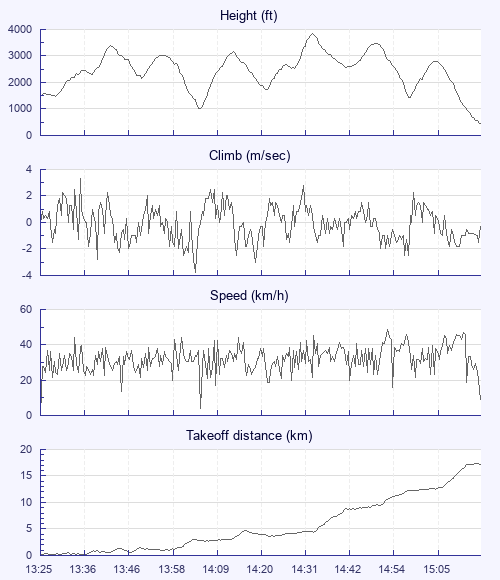
I pushed forward and took a climb well forward from the ridge & pushed out further before taking another climb. Working cross wind was hard work with slow progress & it very nearly landed me on the deck. I found a low save over a small tree covered hill at the south end of the Pandy ridge which took me back to a decent height. Pushing on lost that height pretty quickly. The next climb took me towards the mountains, up to base & a glide right over the the top of Sugar Loaf mountain. At this point I was under the big clouds & glad of having done an SIV course a couple of weeks ago. Rock & roll! One more climb took me to Crickhowell & the campsite was tempting. But I found one more climb & followed the river Usk to Llangynidr.

Came in a bit short of my selected landing field so plan B field it was. The exit route to the road was a bit mission impossible with some fence limbo, crossing someone's back garden, more fence limbo, dodging electric fences & eventually back out to the road. All done without being shouted at: ), bonus. I spotted another pilot landing in my plan A field so went to meet him. We were met by someone else's retrieve & I got a lift to the village pub which wasn't far, & was a very pleasant spot, to wait for Steve.

I felt a bit deflated after this flight. It was an awful lot of work for little distance. 6 climbs & 1hr 53 minutes of air time would have got me 40Km any other day. But actually its longer than any of the Wales flights I did last year, I cracked some real low saves, deliberate cross winding was a first for me & crossing Sugar Loaf was pretty epic: )

Use this page to set various display Options. You can choose which units are used to display flight data, which map to show when the starts and which tab to show each time you view a flight.
Units settings

Metric units are used by default for the Statistics and XC Player pages, except for Height data which is shown in feet. You can choose your own custom settings here.

Height:
Speed:
Climb:
Distance:
  Use default
XC Player settings

When the XC Player starts, the track data is shown on the Hybrid map. You can choose a different map here.

Main Map:
  Use default
Tab settings

The first tab shown when you view a flight is the Flight Map. You can choose a different tab here.

First Tab:
  Use default
Notes

This page uses cookies to save your settings for future visits.

If you have disabled cookies for this site then any changes you make will not be saved.