Xc Title
User:Guest
Naviter advert
Warwick Lister-Kaye  All flights
National League 2018
Flight type image
Turnpoint Flight on a Paraglider
Club
Highland
Glider
Skywalk Chili 4
Date
19th July 2018
Start
12:06
Finish
13:03
Duration
57mins
Takeoff
Strath Rusdale
Landing
Nr Edderton
Coords
Takeoff
57.76850, -4.37798
Start
57.76737, -4.36633
TP1
57.75443, -4.38642
TP2
57.76190, -4.39722
TP3
57.73162, -4.28302
Finish
57.84460, -4.19410
Landing
57.84465, -4.19468
Distances and Score
Leg 1
1.87k
Leg 2
1.05k
Leg 3
7.59k
Leg 4
13.65k
Total
24.16k
Score
24.2
Open Distance
Total
15.5k
Filename
Use full pilot name
Download
Validated
Yes
Flight map
Notes

This map gives an overview of the flight, using the turnpoints to plot the track.

Use the for a detailed map and flight track.

Duration 0:00   Takeoff Distance 0
Controls
To animate the flight: click a point on the track, use the slider, or click the Play button.
slider
slider
Speed
Speed
Slower
Faster
Track color
No data
Highlights
Track data
Time: No data
Height:
Climb:
Speed:
Interval:
Units
Height: metres
Climb: m/sec
Speed: km/h
Distance: km
chart
Notes

Climb and Speed averaged over 4 second intervals.

These values may be lower than those shown by a flight instrument, which has access to continuous raw data.

Red values indicate suspect data, because the tracklog contains invalid points.

Metric units are used for all chart data, except for Height which is shown in feet.

Height   -   GPS data
Maximum Height
[12:41:10]
3642 ft
Lowest Save
[12:51:46]
1818 ft
Takeoff Height
[12:03:13]
1752 ft
Landing Height
[13:03:46]
30 ft
Total Ascent 6355 ft
Height Gain
Above Takeoff 1890 ft
Units
Climb   -   Pressure data
Maximum Climb
[12:10:11]
5.8 m/s
Minimum Climb
[12:20:48]
-5.5 m/s
Units
Speed
Maximum Speed
[12:41:42]
84.0 km/h
Average Speed
around course
25.3 km/h
Average Speed
over track length
34.5 km/h
Units
Tracklog
Flight Duration 1hr
Track Points 2282
Recording Interval 2 secs
Statistics Interval 4 secs
Track Length 34.8 km
Invalid Positions
[< 1%]
6
Units
Flight instrument
Type Flyskyhy
Model 6.11
Firmware 6.11
Notes

Climb and Speed averaged over 4 second intervals.

These values may be lower than those shown by a flight instrument, which has access to continuous raw data.

Red values indicate suspect data, because the tracklog contains invalid points.

Average Speed around course is measured from Start to Finish points.

Track Length is the cumulative distance between track points from Takeoff to Landing.

You can change the default units displayed - see the Options page.

Very interesting day out with Gavin today. We walked up Cnoc an t-Sithean Mor on the north side of Strath Rusdale. Wind was just about soarable and cloud cover circa 90%. It looked windy higher up to me. We discussed an XC downwind but I wasn't keen due to various factors (blisters, time constraint, windy higher up etc), so we figured we'd just boat about in front of the hill for a bit. It didn't look very thermic anyway. Wrong!

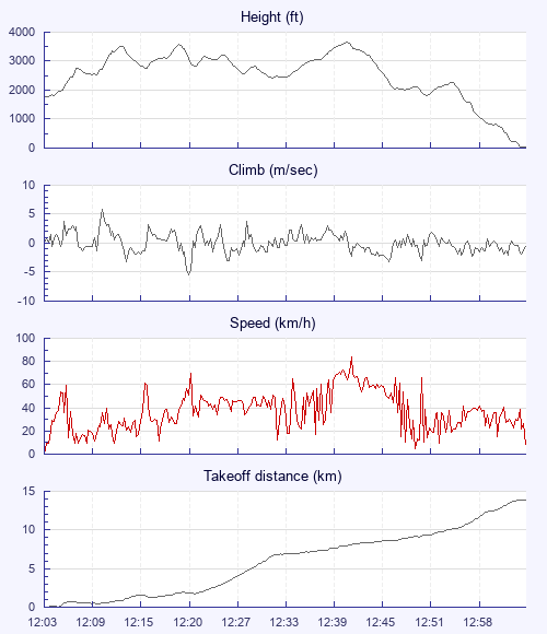
We launched into ubiquitous and powerful lift. Everywhere we went we were going up at between 0.5 - 5 mps! I was nervous as we got pulled higher & higher towards the total cloud cover. We put in big ears, did 360s and used full bar to try to keep away from base. At one point I watched Gavin - with big ears in - rocketing up at 3mps!

We decided to stay below 1000m, giving us a decent margin below base. We had to work hard to achieve that. We pushed out towards Alness & flatter, lower terrain. Things calmed down a bit. We decided that an XC downwind was on after all. We cruised along in gentle lift for several kms and finally hit sink! Then we couldn't find a therm for a bit & when we did it was broken and nasty. Gavin flew it better than I did and bought himself another 10kms or so. I landed in a field near Edderton. Gavin crossed the Dornoch Firth and landed up near Loch Fleet. Probably a 35km XC for Gav.

The views throughout the flight were awesome. It's the first time I've flown an XC near the coast and it was awesome to see the rigs in the Cromarty Firth and the east coast and to the west we could see Stac Polly & Cul Mor.

The retrieve involved quite a bit of hitch hiking. Both of us had a lot of traffic pass us without stopping. B******ds!

All in all though a great day out. Where the hell did all that lift come from?

Use this page to set various display Options. You can choose which units are used to display flight data, which map to show when the starts and which tab to show each time you view a flight.
Units settings

Metric units are used by default for the Statistics and XC Player pages, except for Height data which is shown in feet. You can choose your own custom settings here.

Height:
Speed:
Climb:
Distance:
  Use default
XC Player settings

When the XC Player starts, the track data is shown on the Hybrid map. You can choose a different map here.

Main Map:
  Use default
Tab settings

The first tab shown when you view a flight is the Flight Map. You can choose a different tab here.

First Tab:
  Use default
Notes

This page uses cookies to save your settings for future visits.

If you have disabled cookies for this site then any changes you make will not be saved.