Xc Title
User:Guest
Ozone advert
Brian Stewart  All flights
National League 2019
Flight type image
Turnpoint Flight on a Paraglider
Club
Pennine
Glider
Advance Sigma 10
Date
11th April 2019
Start
12:34
Finish
17:03
Duration
4hrs 28mins
Takeoff
Whernside
Landing
Langwathby
Coords
Takeoff
54.21615, -2.40913
Start
54.21187, -2.41480
TP1
54.23970, -2.37468
TP2
54.22042, -2.40968
TP3
54.19058, -2.37777
Finish
54.70543, -2.67303
Landing
54.70252, -2.67337
Distances and Score
Leg 1
4.06k
Leg 2
3.13k
Leg 3
3.92k
Leg 4
60.43k
Total
71.54k
Score
71.5
Open Distance
Total
60.4k
Filename
Use full pilot name
Download
Validated
Yes
Flight map
Notes

This map gives an overview of the flight, using the turnpoints to plot the track.

Use the for a detailed map and flight track.

Duration 0:00   Takeoff Distance 0
Controls
To animate the flight: click a point on the track, use the slider, or click the Play button.
slider
slider
Speed
Speed
Slower
Faster
Track color
No data
Highlights
Track data
Time: No data
Height:
Climb:
Speed:
Interval:
Units
Height: metres
Climb: m/sec
Speed: km/h
Distance: km
chart
Notes

Climb and Speed averaged over 4 second intervals.

These values may be lower than those shown by a flight instrument, which has access to continuous raw data.

Metric units are used for all chart data, except for Height which is shown in feet.

Height   -   GPS data
Maximum Height
[14:23:09]
4580 ft
Lowest Save
[15:45:47]
1440 ft
Takeoff Height
[12:28:53]
1939 ft
Landing Height
[17:05:37]
335 ft
Total Ascent 31188 ft
Height Gain
Above Takeoff 2641 ft
Maximum 3051 ft
Low Point
as Lowest Save
1440 ft
High Point
[16:00:01]
4491 ft
Units
Climb   -   Pressure data
Maximum Climb
[15:50:58]
4.0 m/s
Minimum Climb
[17:02:13]
-5.3 m/s
Units
Speed
Maximum Speed
[15:02:46]
56.7 km/h
Average Speed
around course
16.0 km/h
Average Speed
over track length
31.9 km/h
Units
Tracklog
Flight Duration 4hrs 36mins
Track Points 16585
Recording Interval 1 secs
Statistics Interval 4 secs
Track Length 147.0 km
Units
Flight instrument
Type Xc_tracer_ii
Model Not Set
Firmware Xc_tracer_ii_r09
Notes

Climb and Speed averaged over 4 second intervals.

These values may be lower than those shown by a flight instrument, which has access to continuous raw data.

Average Speed around course is measured from Start to Finish points.

Track Length is the cumulative distance between track points from Takeoff to Landing.

You can change the default units displayed - see the Options page.

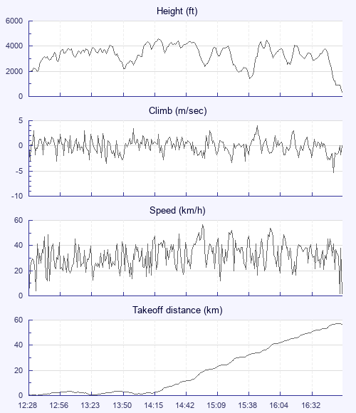
Thanks Jim Ashley for the choice of site, I thought the wind was was too far South. Driving through Ingleton we nearly turned back under the uniform grey blanket, but we put our faith in the weather forecast which turned out to be spot on. A triangle around the 3 peaks was set, but after an hour of vainly pushing upwind, Ingleborough wasn't getting any closer, the thermals were rough and spring like and the southerly wind was making life near the hill very unpleasant. Poor Jim, after persuading Graham and I to join him, landed early and had to console himself with a pint and a nice view of Ribblehead viaduct.

Graham and I decided we'd go over the back, and found that the clouds were behaving just like the textbooks say they should. With hindsight we could probably have pushed faster but lacked the confidence to leave the climbs early. Arriving at the M6 we debated pushing on towards the Lakes, but the clouds drew us along the motorway instead. Both of us had low saves at Tebay, and I was privileged to share a 2000' climb with a true king of the sky - a buzzard that stayed just in front of my leading edge all the way to base.

Landing at Langwathby I set up for an empty field but got it wrong and had to stall it into the field downwind as I wouldn't clear the fence. Then bundle up my glider and run for the gate as a herd of frisky cows galloped towards me. I swear one of them was trying to head me off, but I made the gate, throwing myself, still in the harness, and the glider over it in an ungainly heap. Note to self: must stop crashing on landing.

Big thanks to Jim Ashley for following us in Graham's car and a speedy pickup.

Use this page to set various display Options. You can choose which units are used to display flight data, which map to show when the starts and which tab to show each time you view a flight.
Units settings

Metric units are used by default for the Statistics and XC Player pages, except for Height data which is shown in feet. You can choose your own custom settings here.

Height:
Speed:
Climb:
Distance:
  Use default
XC Player settings

When the XC Player starts, the track data is shown on the Hybrid map. You can choose a different map here.

Main Map:
  Use default
Tab settings

The first tab shown when you view a flight is the Flight Map. You can choose a different tab here.

First Tab:
  Use default
Notes

This page uses cookies to save your settings for future visits.

If you have disabled cookies for this site then any changes you make will not be saved.