Xc Title
User:Guest
Ozone advert
Richard Meek  All flights
National League 2021
Flight type image
Turnpoint Flight on a Paraglider
Club
Dales
Glider
Ozone Zeno
Date
1st June 2021
Start
11:07
Finish
18:10
Duration
7hrs 2mins
Takeoff
Semer Water
Landing
Lanark
Coords
Takeoff
54.28868, -2.13950
Start
54.28348, -2.14638
TP1
54.28700, -2.12825
TP2
54.28285, -2.14603
TP3
55.67357, -3.80267
Finish
55.67465, -3.76915
Landing
55.67815, -3.77277
Distances and Score
Leg 1
1.24k
Leg 2
1.25k
Leg 3
187.66k
Leg 4
2.11k
Total
192.26k
Score
192.3
Open Distance
Total
188.0k
Filename
Use full pilot name
Download
Validated
Yes
Flight map
Notes

This map gives an overview of the flight, using the turnpoints to plot the track.

Use the for a detailed map and flight track.

Duration 0:00   Takeoff Distance 0
Controls
To animate the flight: click a point on the track, use the slider, or click the Play button.
slider
slider
Speed
Speed
Slower
Faster
Track color
No data
Highlights
Track data
Time: No data
Height:
Climb:
Speed:
Interval:
Units
Height: metres
Climb: m/sec
Speed: km/h
Distance: km
chart
Notes

Climb and Speed averaged over 4 second intervals.

These values may be lower than those shown by a flight instrument, which has access to continuous raw data.

Metric units are used for all chart data, except for Height which is shown in feet.

Height   -   GPS data
Maximum Height
[16:04:59]
6056 ft
Lowest Save
[13:58:13]
1627 ft
Takeoff Height
[10:37:34]
1496 ft
Landing Height
[18:14:03]
791 ft
Total Ascent 51440 ft
Height Gain
Above Takeoff 4560 ft
Maximum 4606 ft
Low Point
[10:52:08]
1450 ft
High Point
as Maximum Height
6056 ft
Units
Climb   -   Pressure data
Maximum Climb
[16:40:38]
4.3 m/s
Minimum Climb
[18:03:38]
-6.8 m/s
Units
Speed
Maximum Speed
[13:49:06]
77.4 km/h
Average Speed
around course
27.3 km/h
Average Speed
over track length
38.3 km/h
Units
Tracklog
Flight Duration 7hrs 36mins
Track Points 27390
Recording Interval 1 secs
Statistics Interval 4 secs
Track Length 291.5 km
Units
Flight instrument
Type Xiaomi Mi Max 3 10
Model Not Set
Firmware 0.9.5.3
Notes

Climb and Speed averaged over 4 second intervals.

These values may be lower than those shown by a flight instrument, which has access to continuous raw data.

Average Speed around course is measured from Start to Finish points.

Track Length is the cumulative distance between track points from Takeoff to Landing.

You can change the default units displayed - see the Options page.

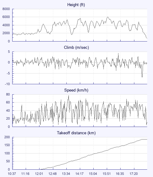
Tricky flight to begin with, took an hour and a half to leave the hill with Jake, Pete and Jacob. Nearly landed after 30 mins just east of Great Shunner Fell but some dogged scratching got me out of that particular hole.

On my own as I transitioned into the Eden valley, Jake spotted me just a couple of km behind him and called me on the radio. Try as I might I couldn't quite catch up with him, closest I got was about one km.

Climbed to base at about 5,500' to cruise across a blue hole before Carlisle. Jake didn't find anything and got decked, I stumbled into a little sustainer which allowed me to push on to a great looking cloud over Carlisle.

Pete caught up a bit north of Carlisle and we flew together for the next 50k or so. The air was quite lively in places, I saw Pete take a front collapse which he handled superbly and took it from bag of washing to flying again in 3 seconds. A little later I had one as well as we battled a feisty lee side thermal. Not long after our collapses we got separated and Pete landed.

Pressing on to my goal the sky was looking good but came to a massive area of wind farms, forest and boonies to the east of Camps reservoir. Decided I didn't fancy that so hung a left (west of course line) to a more civilized route. Started regretting that decision as I got low over some other wind mills but at least these were spread out and there were plenty of landing options without the risk of being chopped up by the windmill blades.

25k out the ridge line to the north west of Camps reservoir provided the climb which let me start to believe goal was possible. That took me to 3,8 and from there the course line took me directly over Tinto which had a really good cloud above it. I took that final climb mmuch higher than required leaving me with a final glide of 5:1. But with the airspace dropping down to 4,5 and the cloud street to Lanark working really well I had to burn off a fair bit to keep legal.

Fish and chip tea in Lanark, train to Penrith then car back to Hawes (thanks Jake, top man)

PB for distance and duration. What a day.

Use this page to set various display Options. You can choose which units are used to display flight data, which map to show when the starts and which tab to show each time you view a flight.
Units settings

Metric units are used by default for the Statistics and XC Player pages, except for Height data which is shown in feet. You can choose your own custom settings here.

Height:
Speed:
Climb:
Distance:
  Use default
XC Player settings

When the XC Player starts, the track data is shown on the Hybrid map. You can choose a different map here.

Main Map:
  Use default
Tab settings

The first tab shown when you view a flight is the Flight Map. You can choose a different tab here.

First Tab:
  Use default
Notes

This page uses cookies to save your settings for future visits.

If you have disabled cookies for this site then any changes you make will not be saved.