Xc Title
User:Guest
UK Airsports advert
Carl Foster  All flights
National League 2021
Flight type image
Tow-launch Turnpoint Flight on a Paraglider
Club
Norfolk
Glider
Ozone Delta 4
Date
12th June 2021
Start
12:58
Finish
15:15
Duration
2hrs 16mins
Takeoff
Hill Farm
Landing
Nr Badingham
Coords
Takeoff
52.69160, 0.81735
Start
52.69160, 0.81735
TP1
52.69057, 0.81020
TP2
52.26998, 1.42963
TP3
52.24770, 1.39190
Finish
52.25080, 1.37912
Landing
52.25028, 1.38087
Distances and Score
Leg 1
0.50k
Leg 2
62.94k
Leg 3
3.58k
Leg 4
0.94k
Total
67.96k
Score
68.0
Open Distance
Total
63.2k
Filename
Use full pilot name
Download
Validated
Yes
Flight map
Notes

This map gives an overview of the flight, using the turnpoints to plot the track.

Use the for a detailed map and flight track.

Duration 0:00   Takeoff Distance 0
Controls
To animate the flight: click a point on the track, use the slider, or click the Play button.
slider
slider
Speed
Speed
Slower
Faster
Track color
No data
Highlights
Track data
Time: No data
Height:
Climb:
Speed:
Interval:
Units
Height: metres
Climb: m/sec
Speed: km/h
Distance: km
chart
Notes

Climb and Speed averaged over 4 second intervals.

These values may be lower than those shown by a flight instrument, which has access to continuous raw data.

Metric units are used for all chart data, except for Height which is shown in feet.

Height   -   GPS data
Maximum Height
[14:07:27]
3763 ft
Lowest Save
[14:21:17]
715 ft
Takeoff Height
[12:58:22]
203 ft
Landing Height
[15:16:32]
0 ft
Total Ascent 15827 ft
Height Gain
Above Takeoff 3560 ft
Units
Climb   -   Pressure data
Maximum Climb
[12:59:10]
5.3 m/s
Minimum Climb
[13:36:22]
-4.5 m/s
Units
Speed
Maximum Speed
[13:47:42]
73.8 km/h
Average Speed
around course
29.8 km/h
Average Speed
over track length
40.4 km/h
Units
Tracklog
Flight Duration 2hrs 18mins
Track Points 8291
Recording Interval 1 secs
Statistics Interval 4 secs
Track Length 93.1 km
Units
Flight instrument
Type Oudie 4 Full
Model Y
Firmware 9.33.001
Notes

Climb and Speed averaged over 4 second intervals.

These values may be lower than those shown by a flight instrument, which has access to continuous raw data.

Average Speed around course is measured from Start to Finish points.

Track Length is the cumulative distance between track points from Takeoff to Landing.

You can change the default units displayed - see the Options page.

Quite an unexpected flight, although I thought the day hD a lot of potential, there was a lot 9f talk about it being to windy to tow, and our Winchmore also said he would come out to winch until later. I also had a number of Tow Conversion pilots turning up so I figured I would winch the pi, ots wanting to go xc up and whenthey have flown the nest, I would work on the theory with the TC pilots with the aim to get them flying in the evening. As it turned out another winchman was planning on flying later on in the day, so offered to to winch, while I had a fly.

Be rude not to take, it but having no water, no coat I took off, bad start, left hand got caught in ymy risers some how brake pinged out of my hand in to the lines, with the wing veering off line to my right, I managed to reach up with my hand still stuck and hook the brake line with my little finger and bring the wing online, with a little height I could free my left hand and compose myself for the rest of the Tow.

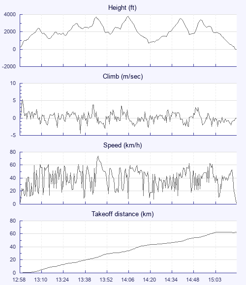
Released and thought this is lifty, very little searching I started to climb, with some serious drift. I needed to crosswind pretty quick and not overly high to make sure I missed Norwich airspace and flew through Shipdham ATZ which is only activate day notam, but still the first time actually flew through it, seemed strange looking down the upwind side of the runway, I got quite low from the crosswinding. Finally getting up to around 3k ft. Was fairly chilli in just a thin jumper, but not bad.

The rest of the flight was pretty much text book climb glide down wind climb, the pilot who got away 3 lines earlier was 16km in front according to my flarm and 16km he remained for most of the flight, I never did see him in the air. I noticed after wards we took different routes around the next ATZ we did have to avoid, me going by on the northern side while Darren took the westerly side.

Down to 800ft working very light lift, A buzzard and red kite appeared from nowhere, cross wind from me, I left what I had to join them, thinking I've made a mistake leaving lift low for something better, but was rewarded with a good climb to 3k again with the birds getting really close what a blessing this sport can be. They certainly saved me.

Some thermally with the sail planes coming out of Tibenham. Made me feel a. Title uneasy, but stuck with it and another climb to base.

The end of the flight I just ran out of skill and experience dealing with the sea breeze, my last main climb I think was in the converging air mass, it felt a lot colder in fact cold enough for me not to take those few extra turns near base. A few cumulus to my east towards the coast but I didn't think I could reach the coast from 3500ft and worried I would cross the sea breeze front, so turned more southerly and eventually westerly but still got the wrong side of it, wasn't overly pleasant flying in the mixing air and eventually landed in the sea breeze.

Great flight, a UK PB for me and even better being from my local club. Thanks to all at the field that make it happen, towing is very much a team sport.

Use this page to set various display Options. You can choose which units are used to display flight data, which map to show when the starts and which tab to show each time you view a flight.
Units settings

Metric units are used by default for the Statistics and XC Player pages, except for Height data which is shown in feet. You can choose your own custom settings here.

Height:
Speed:
Climb:
Distance:
  Use default
XC Player settings

When the XC Player starts, the track data is shown on the Hybrid map. You can choose a different map here.

Main Map:
  Use default
Tab settings

The first tab shown when you view a flight is the Flight Map. You can choose a different tab here.

First Tab:
  Use default
Notes

This page uses cookies to save your settings for future visits.

If you have disabled cookies for this site then any changes you make will not be saved.