Xc Title
User:Guest
Ozone advert
Mike Byfield  All flights
National League 2021
Flight type image
Turnpoint Flight on a Paraglider
Club
Thames Valley
Glider
Advance Omega X-Alps 3
Date
23rd June 2021
Start
12:00
Finish
17:58
Duration
5hrs 57mins
Takeoff
Hay Bluff
Landing
Nr Toothill
Coords
Takeoff
52.02267, -3.10395
Start
52.02277, -3.10440
TP1
51.84580, -2.99775
TP2
51.73748, -2.29507
TP3
51.56390, -2.01263
Finish
51.54825, -1.81052
Landing
51.54725, -1.81852
Distances and Score
Leg 1
21.01k
Leg 2
49.96k
Leg 3
27.48k
Leg 4
14.13k
Total
112.58k
Score
112.6
Open Distance
Total
104.0k
Filename
Use full pilot name
Download
Validated
Yes
Flight map
Notes

This map gives an overview of the flight, using the turnpoints to plot the track.

Use the for a detailed map and flight track.

Duration 0:00   Takeoff Distance 0
Controls
To animate the flight: click a point on the track, use the slider, or click the Play button.
slider
slider
Speed
Speed
Slower
Faster
Track color
No data
Highlights
Track data
Time: No data
Height:
Climb:
Speed:
Interval:
Units
Height: metres
Climb: m/sec
Speed: km/h
Distance: km
chart
Notes

Climb and Speed averaged over 4 second intervals.

These values may be lower than those shown by a flight instrument, which has access to continuous raw data.

Red values indicate suspect data, because the tracklog contains invalid points.

Metric units are used for all chart data, except for Height which is shown in feet.

Height   -   GPS data
Maximum Height
[14:48:22]
5535 ft
Lowest Save
[16:12:00]
1010 ft
Takeoff Height
[12:00:50]
2221 ft
Landing Height
[18:01:23]
331 ft
Total Ascent 40938 ft
Height Gain
Above Takeoff 3314 ft
Maximum 4301 ft
Low Point
as Lowest Save
1010 ft
High Point
[16:22:22]
5312 ft
Units
Climb   -   GPS data
Maximum Climb
[12:05:26]
4.3 m/s
Minimum Climb
[15:18:58]
-6.0 m/s
Units
Speed
Maximum Speed
[15:13:22]
61.2 km/h
Average Speed
around course
18.9 km/h
Average Speed
over track length
35.7 km/h
Units
Tracklog
Flight Duration 6hrs
Track Points 21634
Recording Interval 1 secs
Statistics Interval 4 secs
Track Length 214.7 km
Invalid Heights
[< 1%]
4
Units
Flight instrument   -   reported as
Flymaster F1, V2.3, S/N 425
Notes

Climb and Speed averaged over 4 second intervals.

These values may be lower than those shown by a flight instrument, which has access to continuous raw data.

Red values indicate suspect data, because the tracklog contains invalid points.

Average Speed around course is measured from Start to Finish points.

Track Length is the cumulative distance between track points from Takeoff to Landing.

You can change the default units displayed - see the Options page.

Light northerly winds were forecast Tuesday evening so the Blorenge was the favoured site. Wednesday morning and all change. Now Hay Bluff was the chosen site on telegram. I'd already arranged to meet Ali at Abergavenny train station, but messages from Peggy, Agi and Norris convinced me to amend the plan. Site guide read, parking found, pin received - We were off!

Having never been to Hay we took the direct, road closed route. Luckily for us we were able to pass where part of the road had fallen away. On arrival Hay looked magnificent. Students on training gliders in the bottom field, speed wings skimming the hillside, and several wings soaring. Everything was so exciting I almost forgot about the hard, steep carry up. Almost!

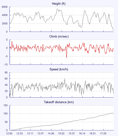
A triangle was the original plan, but a significant breeze put an end to that idea. The new plan was 3hrs airtime and to cross the river. Ooooh! Pilots wasted no time in getting away, as high cloud was creeping nearer. Peggy and Tosh were the first away with Paul J leading the second gaggle. By now you had to pick your moment to launch as the breeze was quite strong. Even with a breeze and steady 1 and 2mps climbs the going was painfully slow. Ali and I tracked along the high ground and stuck together as best we could. The first 20 or so kilometres were all about choosing a good line.

But enough about the conditions. We crossed the river Severn! Yeah! We had plenty of height, but it was still a scary thing to do. And the views were captivating. Wow!

After that we flew a bit, Ali landed just before Selsley, I flew a bit more then landed at Swindon.

First flight from Hay and first crossing of the Severn, in 6 hrs - Wow! Nuff said: -)

Use this page to set various display Options. You can choose which units are used to display flight data, which map to show when the starts and which tab to show each time you view a flight.
Units settings

Metric units are used by default for the Statistics and XC Player pages, except for Height data which is shown in feet. You can choose your own custom settings here.

Height:
Speed:
Climb:
Distance:
  Use default
XC Player settings

When the XC Player starts, the track data is shown on the Hybrid map. You can choose a different map here.

Main Map:
  Use default
Tab settings

The first tab shown when you view a flight is the Flight Map. You can choose a different tab here.

First Tab:
  Use default
Notes

This page uses cookies to save your settings for future visits.

If you have disabled cookies for this site then any changes you make will not be saved.