Xc Title
User:Guest
UK Airsports advert
Brian Greenwell  All flights
National League 2021
Flight type image
Open Distance on a Paraglider
Club
Southern
Glider
Advance Sigma 10
Date
20th August 2021
Start
11:52
Finish
13:09
Duration
1hr 17mins
Takeoff
Caburn
Landing
Nr Rother District
Coords
Takeoff
50.86110, 0.04940
Start
50.86275, 0.04433
Finish
50.87413, 0.48710
Landing
50.87462, 0.48532
Distance and Score
Total
31.20k
Score
31.2
Filename
Use full pilot name
Download
Validated
Yes
Flight map
Notes

This map gives an overview of the flight, using the turnpoints to plot the track.

Use the for a detailed map and flight track.

Duration 0:00   Takeoff Distance 0
Controls
To animate the flight: click a point on the track, use the slider, or click the Play button.
slider
slider
Speed
Speed
Slower
Faster
Track color
No data
Highlights
Track data
Time: No data
Height:
Climb:
Speed:
Interval:
Units
Height: metres
Climb: m/sec
Speed: km/h
Distance: km
chart
Notes

Climb and Speed averaged over 4 second intervals.

These values may be lower than those shown by a flight instrument, which has access to continuous raw data.

Red values indicate suspect data, because the tracklog contains invalid points.

Metric units are used for all chart data, except for Height which is shown in feet.

Height   -   GPS data
Maximum Height
[12:48:52]
2628 ft
Lowest Save
[12:59:23]
673 ft
Takeoff Height
[11:50:15]
492 ft
Landing Height
[13:11:28]
79 ft
Total Ascent 8373 ft
Height Gain
Above Takeoff 2136 ft
Maximum 2224 ft
Low Point
[11:54:11]
404 ft
High Point
as Maximum Height
2628 ft
Units
Climb   -   Pressure data
Maximum Climb
[12:37:04]
3.5 m/s
Minimum Climb
[12:19:35]
-2.5 m/s
Units
Speed
Maximum Speed
[12:47:12]
67.5 km/h
Average Speed
around course
24.3 km/h
Average Speed
over track length
38.3 km/h
Units
Tracklog
Flight Duration 1hr 21mins
Track Points 4874
Recording Interval 1 secs
Statistics Interval 4 secs
Track Length 51.9 km
Invalid Positions
[< 1%]
7
Units
Flight instrument
Type Flyskyhy
Model 7.2
Firmware 7.2
Notes

Climb and Speed averaged over 4 second intervals.

These values may be lower than those shown by a flight instrument, which has access to continuous raw data.

Red values indicate suspect data, because the tracklog contains invalid points.

Average Speed around course is measured from Start to Finish points.

Track Length is the cumulative distance between track points from Takeoff to Landing.

You can change the default units displayed - see the Options page.

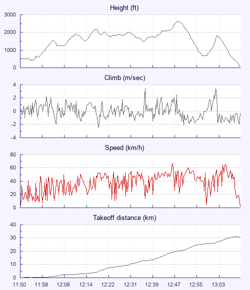
My first decent XC. Quite an exciting flight really. Was breezy on hill and lots were waiting for it to calm down. A SBF was visible approaching from SW with a westerly wind on the hill. The wind dropped, lots of pilots launched and quickly got some height, I quickly unpacked and launched a few minutes later. I almost missed the SBF that I think was towards the back of take off. Pilots were searching out front but I gambled on it being behind us and found a climb into it that committed me to an XC of some kind. Cloud base was about 2000' so not much to play with.

I drifted east trying to find bits of SBF lift with some success, pushing east when I got to cloud base or lost the lift.

Inland from Polegate there seemed to be a larger area of convergence where I was able to just push downwind.

Past Hailsham I got into some strong lift and had to spiral dive out of cloud over Hearstmonceux. That got the pulse racing.

Then on half bar I had an asymmetric collapse that had to be pumped out - a new experience for me but all good.

Realising I needed to push towards the sea to avoid further cloud suck I eventually lost the lift and landed in a nicely cut grass field close to a footpath to Crowhurst. Phew.

Use this page to set various display Options. You can choose which units are used to display flight data, which map to show when the starts and which tab to show each time you view a flight.
Units settings

Metric units are used by default for the Statistics and XC Player pages, except for Height data which is shown in feet. You can choose your own custom settings here.

Height:
Speed:
Climb:
Distance:
  Use default
XC Player settings

When the XC Player starts, the track data is shown on the Hybrid map. You can choose a different map here.

Main Map:
  Use default
Tab settings

The first tab shown when you view a flight is the Flight Map. You can choose a different tab here.

First Tab:
  Use default
Notes

This page uses cookies to save your settings for future visits.

If you have disabled cookies for this site then any changes you make will not be saved.