Xc Title
User:Guest
UK Airsports advert
Lawrie Noctor  All flights
National League 2021
Flight type image
Turnpoint Flight on a Paraglider
Club
Derbyshire
Glider
Ozone Zeolite GT
Date
28th August 2021
Start
11:41
Finish
17:11
Duration
5hrs 30mins
Takeoff
Mam Tor
Landing
Leominster
Coords
Takeoff
53.35088, -1.80810
Start
53.34870, -1.81000
TP1
53.34600, -1.76658
TP2
52.54502, -2.50695
TP3
52.54540, -2.48865
Finish
52.22243, -2.73725
Landing
52.22462, -2.73585
Distances and Score
Leg 1
2.91k
Leg 2
102.09k
Leg 3
1.24k
Leg 4
39.73k
Total
145.97k
Score
146.0
Open Distance
Total
141.1k
Filename
Use full pilot name
Download
Validated
Yes
Flight map
Notes

This map gives an overview of the flight, using the turnpoints to plot the track.

Use the for a detailed map and flight track.

Duration 0:00   Takeoff Distance 0
Controls
To animate the flight: click a point on the track, use the slider, or click the Play button.
slider
slider
Speed
Speed
Slower
Faster
Track color
No data
Highlights
Track data
Time: No data
Height:
Climb:
Speed:
Interval:
Units
Height: metres
Climb: m/sec
Speed: km/h
Distance: km
chart
Notes

Climb and Speed averaged over 4 second intervals.

These values may be lower than those shown by a flight instrument, which has access to continuous raw data.

Red values indicate suspect data, because the tracklog contains invalid points.

Metric units are used for all chart data, except for Height which is shown in feet.

Height   -   GPS data
Maximum Height
[15:47:11]
5039 ft
Lowest Save
[14:54:28]
1142 ft
Takeoff Height
[11:37:12]
1588 ft
Landing Height
[17:14:43]
240 ft
Total Ascent 46640 ft
Height Gain
Above Takeoff 3451 ft
Maximum 3898 ft
Low Point
as Lowest Save
1142 ft
High Point
as Maximum Height
5039 ft
Units
Climb   -   Pressure data
Maximum Climb
[16:04:38]
4.0 m/s
Minimum Climb
[17:08:05]
-4.5 m/s
Units
Speed
Maximum Speed
[16:45:34]
75.2 km/h
Average Speed
around course
26.5 km/h
Average Speed
over track length
39.9 km/h
Units
Tracklog
Flight Duration 5hrs 37mins
Track Points 20252
Recording Interval 1 secs
Statistics Interval 4 secs
Track Length 224.5 km
Invalid Positions
[< 1%]
51
Units
Flight instrument
Type Xc_tracer_ii_flarm
Model Not Set
Firmware Xc_tracer_flarm_r08
Notes

Climb and Speed averaged over 4 second intervals.

These values may be lower than those shown by a flight instrument, which has access to continuous raw data.

Red values indicate suspect data, because the tracklog contains invalid points.

Average Speed around course is measured from Start to Finish points.

Track Length is the cumulative distance between track points from Takeoff to Landing.

You can change the default units displayed - see the Options page.

Interesting flight yesterday. Having looked at RASP and other forecasts we had about 207km declared. On arriving in the peaks we were greeted with 7/8 cover and about 8-10mph easterly. The cloud cover was interesting as RASP had given a reasonable early start with good thermalling height from 10:00/11:00. We opted to go to Treak and get kit out early and transition to Mam Tor ready for the winds to drop off. As we were preparing the kit the wind dropped off very quickly and we only just made the bottom of Mam Tor from the transition. A very long hot slog up the face of Mam in our gear followed.

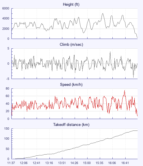
Once on top of Mam we could see others getting ready. Matt Cook and Helen Gant were first off marking a nice little climb in front of take off (thanks) around 11:45 followed by Idris and I. Looking south west there was a gap of blue sky for 5-10km and so we decided to push first towards Bradwell then south west where the nice cumulus was. Pushing south south west through the Peaks, cloud base was only 3400 ish and climbs were slow… Really slow. It then turned into 2hr mince fest just trying to get out of high ground. Our first decent climb was around Ecton marked initially by a sailplane and then a bunch of birds which got us to cloudbase and around 4000ft… Finally!

For the next 20km I was relatively low but at least the glides we longer and less cross wind. Just north of Stafford conditions started getting better with nice climbs and higher base. Given how long it took to leave the Peaks and the time we left the hill I wasn't confident we would make goal but our average XC speed was much faster and increasing. From here it was much more classic conditions with climbs to around 4500-5000ft and nice long fast glides.

Around Cleehill/Ludlow area we decided to call it a day as we knew we could catch a train from Leominster back to Edale. Of course on last 10km glide we had beautiful street ahead of us and we were climbing solidly on full bar… Typical. If we carried on I think we may have got Hay bluff/Aber way however happy to have a flight in good company. Idris Birch.

Use this page to set various display Options. You can choose which units are used to display flight data, which map to show when the starts and which tab to show each time you view a flight.
Units settings

Metric units are used by default for the Statistics and XC Player pages, except for Height data which is shown in feet. You can choose your own custom settings here.

Height:
Speed:
Climb:
Distance:
  Use default
XC Player settings

When the XC Player starts, the track data is shown on the Hybrid map. You can choose a different map here.

Main Map:
  Use default
Tab settings

The first tab shown when you view a flight is the Flight Map. You can choose a different tab here.

First Tab:
  Use default
Notes

This page uses cookies to save your settings for future visits.

If you have disabled cookies for this site then any changes you make will not be saved.