Xc Title
User:Guest
Naviter advert
Andrew Craig  All flights
National League 2021
Flight type image
Turnpoint Flight on a Paraglider
Club
Southern
Glider
Gin Calypso
Date
4th September 2021
Start
13:02
Finish
13:52
Duration
50mins
Takeoff
Kettle Sings
Landing
Near Ledbury
Coords
Takeoff
52.07428, -2.33845
Start
52.07857, -2.33083
TP1
52.06617, -2.34448
TP2
52.06140, -2.29643
TP3
52.08253, -2.30868
Finish
52.03480, -2.46465
Landing
52.03517, -2.46405
Distances and Score
Leg 1
1.67k
Leg 2
3.34k
Leg 3
2.50k
Leg 4
11.94k
Total
19.45k
Score
19.5
Open Distance
Total
12.0k
Filename
Use full pilot name
Download
Validated
Yes
Flight map
Notes

This map gives an overview of the flight, using the turnpoints to plot the track.

Use the for a detailed map and flight track.

Duration 0:00   Takeoff Distance 0
Controls
To animate the flight: click a point on the track, use the slider, or click the Play button.
slider
slider
Speed
Speed
Slower
Faster
Track color
No data
Highlights
Track data
Time: No data
Height:
Climb:
Speed:
Interval:
Units
Height: metres
Climb: m/sec
Speed: km/h
Distance: km
chart
Notes

Climb and Speed averaged over 4 second intervals.

These values may be lower than those shown by a flight instrument, which has access to continuous raw data.

Metric units are used for all chart data, except for Height which is shown in feet.

Height   -   GPS data
Maximum Height
[13:15:11]
4016 ft
Lowest Save
[13:03:19]
1371 ft
Takeoff Height
[12:43:51]
1102 ft
Landing Height
[13:52:47]
190 ft
Total Ascent 8573 ft
Height Gain
Above Takeoff 2913 ft
Maximum 3051 ft
Low Point
[12:49:16]
965 ft
High Point
as Maximum Height
4016 ft
Units
Climb   -   Pressure data
Maximum Climb
[13:10:11]
3.8 m/s
Minimum Climb
[13:16:35]
-3.3 m/s
Units
Speed
Maximum Speed
[13:41:03]
56.7 km/h
Average Speed
around course
23.2 km/h
Average Speed
over track length
31.2 km/h
Units
Tracklog
Flight Duration 1hr 8mins
Track Points 4137
Recording Interval 1 secs
Statistics Interval 4 secs
Track Length 35.8 km
Units
Flight instrument
Type Syride
Model Sys'Nav
Firmware 3.36
Notes

Climb and Speed averaged over 4 second intervals.

These values may be lower than those shown by a flight instrument, which has access to continuous raw data.

Average Speed around course is measured from Start to Finish points.

Track Length is the cumulative distance between track points from Takeoff to Landing.

You can change the default units displayed - see the Options page.

After abandoning my attempt to walk the Ridgeway home from Buckinghamshire (I did a bit about 50 of the 87 miles), I was determined to get some flying in, so set off to Malvern. Friday was pleasant, with climbs under the overcast to 2000 feet - although once it got sunny, I bombed out!

After a night at the lovely Fishponds campsite near Colwall, I returned to a sunny morning at Kettle Sings. It was a bit windy, so Peggy and I had a cup of tea in the car park before walking up to meet Lawrie Noctor, whose Zeolite GT she was planning to try.

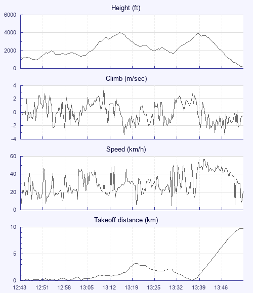
The wind eased, and Lawrie launched and climbed. Peggy wasn't far behind, but it was harder than expected, and she did well to get in for a slope landing rather than going down. But a few more started staying up, and I launched as Peggy found a climb in front.

I found it rough at first, and was very conscious of the proximity of the ground. I couldn't keep up with Lawrie and Peggy, and the first climbs were both brief and windy. But eventually I found one out front that had little drift, and was able to fly well forward without losing too much height.

My objective for the day was to fly the 10k necessary to put this flight into the league (having landed at 8-point-something on Friday), and I turned back to the hill with about 8 done. Fortunately I found another excellent climb that took me back up to 4,000 feet over launchMy mind was made up: downwind! Sadly the clouds there were a bit mushier. I was low by the time I got to Ledbury, where an industrial estate was in shade. I landed a couple of km further on for a total of 19.5.

At this time of year you expect to find plenty of blackberries at the edge of your landing field. What I didn't expect was a couple of dozen freshish sardines just inside the gate. As I looked at them, a rat dashed past, as if to say: "Bugger off so I can get stuck in! "

I set off to walk to Ledbury station, but was picked up by a very nice old lady in a tiny camper, who had to reorganise all its contents to fit me in. On the drive she told me how she and her husband had used to travel around France in larger vans; now, on her own, she'd decided to be a merry widow and take to the road again.

Beside the station I bought tea and cake from a pottery workshop-cum-cafe, and at Colwall station I was kindly picked up by Alan Birtles. Back at the car park, there was more tea and ginger nuts with Peggy and co. A lovely September day.

Use this page to set various display Options. You can choose which units are used to display flight data, which map to show when the starts and which tab to show each time you view a flight.
Units settings

Metric units are used by default for the Statistics and XC Player pages, except for Height data which is shown in feet. You can choose your own custom settings here.

Height:
Speed:
Climb:
Distance:
  Use default
XC Player settings

When the XC Player starts, the track data is shown on the Hybrid map. You can choose a different map here.

Main Map:
  Use default
Tab settings

The first tab shown when you view a flight is the Flight Map. You can choose a different tab here.

First Tab:
  Use default
Notes

This page uses cookies to save your settings for future visits.

If you have disabled cookies for this site then any changes you make will not be saved.