Xc Title
User:Guest
UK Airsports advert
Jacob Cleverley  All flights
National League 2021
Flight type image
Turnpoint Flight on a Paraglider
Club
Pennine
Glider
Date
2nd May 2021
Start
10:27
Finish
15:12
Duration
4hrs 44mins
Takeoff
Bradwell
Landing
Nr Trusthorpe
Coords
Takeoff
53.32070, -1.73022
Start
53.32167, -1.72665
TP1
53.32195, -1.74425
TP2
53.22940, -0.41307
TP3
53.32385, -0.11370
Finish
53.33035, 0.27867
Landing
53.33270, 0.27253
Distances and Score
Leg 1
1.17k
Leg 2
89.40k
Leg 3
22.57k
Leg 4
26.15k
Total
139.29k
Score
139.3
Open Distance
Total
134.8k
Filename
Use full pilot name
Download
Validated
Yes
Flight map
Notes

This map gives an overview of the flight, using the turnpoints to plot the track.

Use the for a detailed map and flight track.

Duration 0:00   Takeoff Distance 0
Controls
To animate the flight: click a point on the track, use the slider, or click the Play button.
slider
slider
Speed
Speed
Slower
Faster
Track color
No data
Highlights
Track data
Time: No data
Height:
Climb:
Speed:
Interval:
Units
Height: metres
Climb: m/sec
Speed: km/h
Distance: km
chart
Notes

Climb and Speed averaged over 4 second intervals.

These values may be lower than those shown by a flight instrument, which has access to continuous raw data.

Red values indicate suspect data, because the tracklog contains invalid points.

Metric units are used for all chart data, except for Height which is shown in feet.

Height   -   GPS data
Maximum Height
[13:42:51]
5702 ft
Lowest Save
[14:46:15]
1119 ft
Takeoff Height
[10:02:16]
1194 ft
Landing Height
[15:22:05]
13 ft
Total Ascent 35502 ft
Height Gain
Above Takeoff 4508 ft
Maximum 4514 ft
Low Point
[10:02:17]
1188 ft
High Point
as Maximum Height
5702 ft
Units
Climb   -   Pressure data
Maximum Climb
[13:40:33]
4.3 m/s
Minimum Climb
[15:14:32]
-5.3 m/s
Units
Speed
Maximum Speed
[13:44:01]
75.6 km/h
Average Speed
around course
29.4 km/h
Average Speed
over track length
39.5 km/h
Units
Tracklog
Flight Duration 5hrs 19mins
Track Points 19190
Recording Interval 1 secs
Statistics Interval 4 secs
Track Length 210.5 km
Invalid Positions
[< 1%]
48
Units
Flight instrument
Type Samsung Sm-j530f 9
Model Not Set
Firmware 0.9.5.2-beta
Notes

Climb and Speed averaged over 4 second intervals.

These values may be lower than those shown by a flight instrument, which has access to continuous raw data.

Red values indicate suspect data, because the tracklog contains invalid points.

Average Speed around course is measured from Start to Finish points.

Track Length is the cumulative distance between track points from Takeoff to Landing.

You can change the default units displayed - see the Options page.

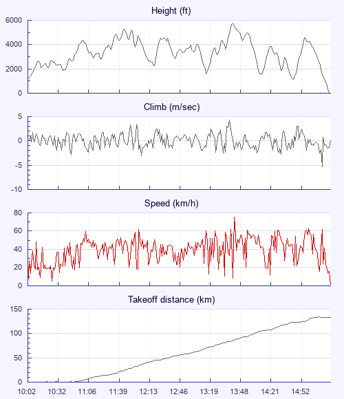
In the morning I was unsure of what we'd get with the likely overdevelopment. I therefore declared Lincoln rather than Skegness, and took off early at the hill as I usually like to do. It was pretty easy to get high and stay high, and our gaggle left the hill really early and got on the way. That initial climb was very wide and messy with seemingly everyone turning in different directions, so I was glad to get up and away without a mid air.

I was a little more conservative than some, which meant I ended up on my own from about 15km onwards. Not to worry, to be honest I quite like flying alone over the back some days. There were some massive clouds about with snow falling, but I was able to piece a nice line through without any trouble.

Lincoln came into view but I was low. Happily the rapeseed fields I was aiming for shot me up, and I had an easy glide into my goal cylinder. Nice to look at the cathedral, and to see two hang gliders too.

Now was decision time. It was really early and I'd got to my highest altitude at Lincoln, plus it was under a big cloud and snowing, so I didn't want to land there. Skegness was a no, because of excessive snow/rain. The more northerly line to the coast was blue with no cumulus, but had been for a while, so I went for that.

Clouds started to form but I got low after a really long glide from Lincoln. I worked everything I could getting a few climbs but not to base. One last low save to base secured the coast. It was fantastic to sit over the sea enjoying the moment, then it started snowing again!

Landed safely and great to get a third 100 and new pb. And at last I'm in the 100 club now the league is open!

Use this page to set various display Options. You can choose which units are used to display flight data, which map to show when the starts and which tab to show each time you view a flight.
Units settings

Metric units are used by default for the Statistics and XC Player pages, except for Height data which is shown in feet. You can choose your own custom settings here.

Height:
Speed:
Climb:
Distance:
  Use default
XC Player settings

When the XC Player starts, the track data is shown on the Hybrid map. You can choose a different map here.

Main Map:
  Use default
Tab settings

The first tab shown when you view a flight is the Flight Map. You can choose a different tab here.

First Tab:
  Use default
Notes

This page uses cookies to save your settings for future visits.

If you have disabled cookies for this site then any changes you make will not be saved.