First proper triangle I've done in the UK. Flew the leg to Upton on my own. Mark Jones was hanging around there looking for company, so we climbed to 5000' and flew back to the hill together.
Happy days.


| Duration | 0:00 | Takeoff Distance | 0 |
| Height: | metres |
| Climb: | m/sec |
| Speed: | km/h |
| Distance: | km |
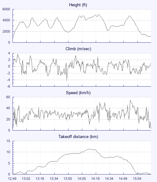
| Height - GPS data | |
| Maximum Height [14:24:38] |
5039 ft |
| Lowest Save [13:51:02] |
1873 ft |
| Takeoff Height [12:49:05] |
1152 ft |
| Landing Height [15:22:47] |
1106 ft |
| Total Ascent | 18438 ft |
| Height Gain | |
| Above Takeoff | 3888 ft |
| Maximum | 3904 ft |
| Low Point [12:49:11] |
1135 ft |
| High Point as Maximum Height |
5039 ft |
| Units | |
| Climb - GPS data | |
| Maximum Climb [12:54:17] |
3.8 m/s |
| Minimum Climb [13:50:13] |
-4.3 m/s |
| Units | |
| Speed | |
| Maximum Speed [14:59:37] |
54.9 km/h |
| Average Speed around course |
13.5 km/h |
| Average Speed over track length |
29.9 km/h |
| Units | |
| Tracklog | |
| Flight Duration | 2hrs 33mins |
| Track Points | 9209 |
| Recording Interval | 1 secs |
| Statistics Interval | 4 secs |
| Track Length | 76.5 km |
| Units | |
| Flight instrument | |
| Type | Flyskyhy |
| Model | 7.0 |
| Firmware | 7.0 |
First proper triangle I've done in the UK. Flew the leg to Upton on my own. Mark Jones was hanging around there looking for company, so we climbed to 5000' and flew back to the hill together.
Happy days.
| Height: | |
| Speed: | |
| Climb: | |
| Distance: |
| Main Map: |
| First Tab: |