Xc Title
User:Guest
Cloudbase Paragliding advert
Phil Clark  All flights
National League 2021
Flight type image
Out and Return on a Paraglider
Club
Dover
Glider
Gin Leopard
Date
27th May 2021
Start
14:11
Finish
16:25
Duration
2hrs 14mins
Takeoff
Golden Ball
Coords
Takeoff
51.37282, -1.82098
Start
51.37287, -1.81935
TP1
51.38220, -1.67323
TP2
51.36027, -1.86545
Finish
51.37287, -1.81935
Landing
51.37297, -1.82078
Distance and Score
Total
27.22k
Multiplier
x 1.50
Score
40.8
Open Distance
Total
13.6k
Filename
Use full pilot name
Download
Validated
Yes
Flight map
Notes

This map gives an overview of the flight, using the turnpoints to plot the track.

Use the for a detailed map and flight track.

Duration 0:00   Takeoff Distance 0
Controls
To animate the flight: click a point on the track, use the slider, or click the Play button.
slider
slider
Speed
Speed
Slower
Faster
Track color
No data
Highlights
Track data
Time: No data
Height:
Climb:
Speed:
Interval:
Units
Height: metres
Climb: m/sec
Speed: km/h
Distance: km
chart
Notes

Climb and Speed averaged over 4 second intervals.

These values may be lower than those shown by a flight instrument, which has access to continuous raw data.

Red values indicate suspect data, because the tracklog contains invalid points.

Metric units are used for all chart data, except for Height which is shown in feet.

Height   -   GPS data
Maximum Height
[14:53:14]
5423 ft
Lowest Save
[16:07:01]
1224 ft
Takeoff Height
[14:03:49]
892 ft
Landing Height
[16:26:20]
899 ft
Total Ascent 16706 ft
Height Gain
Above Takeoff 4531 ft
Maximum 4547 ft
Low Point
[14:03:58]
876 ft
High Point
as Maximum Height
5423 ft
Units
Climb   -   Pressure data
Maximum Climb
[14:11:02]
3.3 m/s
Minimum Climb
[14:42:02]
-3.8 m/s
Units
Speed
Maximum Speed
[15:05:34]
59.4 km/h
Average Speed
around course
12.1 km/h
Average Speed
over track length
32.6 km/h
Units
Tracklog
Flight Duration 2hrs 22mins
Track Points 8551
Recording Interval 1 secs
Statistics Interval 4 secs
Track Length 77.5 km
Invalid Positions
[< 1%]
3
Units
Flight instrument
Type Acer A1-724 4.4.4
Model Not Set
Firmware 0.9.5.3
Notes

Climb and Speed averaged over 4 second intervals.

These values may be lower than those shown by a flight instrument, which has access to continuous raw data.

Red values indicate suspect data, because the tracklog contains invalid points.

Average Speed around course is measured from Start to Finish points.

Track Length is the cumulative distance between track points from Takeoff to Landing.

You can change the default units displayed - see the Options page.

Faffed getting ready and as it switched on I was just a few minutes too slow to chase after Kirsty and Craig, spent a bunch of time trying to escape again with Mike but quit it after 45 minutes. Second attempt chasing kites and crows, with Andrew, Steve, plus others then a third attempt that almost saw me bomb in front of launch and so then I landed to unclip for a bit.

About 2pm it started looking better and more cohesive, it had been really broken and bitty low down, it had felt like we were just punting off into dusties. I had a feeling it would mellow and just be nicer, less spring-like later on in the afternoon. I had this exact conversation with Gary and then climbed out with him in a 2-3m/s ripper about 15 mins later!

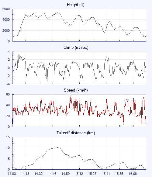
The triangle chat had been Combe first or Uffington first, I set off for Combe from base and started hopping from cu to cu crosswind, got about halfway and realised how rural it was gonna get down below, the thought of bombing that far from civilisation got the better of me. I should have drifted back, on the way back, to tag a point near Marlborough to make a FAI triangle but I'm happy with a solid performance and a total of 4 hours thermal flying for the day.

Use this page to set various display Options. You can choose which units are used to display flight data, which map to show when the starts and which tab to show each time you view a flight.
Units settings

Metric units are used by default for the Statistics and XC Player pages, except for Height data which is shown in feet. You can choose your own custom settings here.

Height:
Speed:
Climb:
Distance:
  Use default
XC Player settings

When the XC Player starts, the track data is shown on the Hybrid map. You can choose a different map here.

Main Map:
  Use default
Tab settings

The first tab shown when you view a flight is the Flight Map. You can choose a different tab here.

First Tab:
  Use default
Notes

This page uses cookies to save your settings for future visits.

If you have disabled cookies for this site then any changes you make will not be saved.