


Shite.
Site.
Success.
It only took 20 years.
The last weekend in May there was five star red covering most of Britain. The sky gods swiftly departed for Tinto in the borders on the Saturday. I was left, probably not going to fly: -(. The dog was pretty sick at the time, the kids were going through the shredder with exams, work had piled up for me. In short, a lot more of the usual. In the end Jenny was well enough for Ruth to suggest I go flying. I jumped at the chance.
I head out to Sutton & Cowling Pinnacles alone but I'm happy enough, there was a usable sky and an actual XC from this "Shite Site" is a task I've been plugging away for a while. It's got to come together at some point, surely?
What makes it a shite site I hear you ask?
The ankle breakers hidden in the ferns for half the places you might want to bottom land. It's no surprise Dougie Lampkin used to come here to practise becoming a world class trials rider in the rock garden.
Narrow lift band. It's a long, shallow gradient up the slope and then the crags and boulders are a kicker at the top, so if you're soaring dynamically you need to be friendly with the rocks. In fact it's also known as Earl Crag to the local grimpers and has some fairly necky gritstone routes.
Rotor on take off. It's a flat top, and whilst it's not as bad as Stags Fell, it has its moments. Last time I was there, I was ground handling to get the feel of conditions and was vertically lifted off the flat top by 5m or so, twice! Interesting.
There's a dry stone wall right behind TO. I suppose you could treat it as some sort of arrestor / safety feature, bringing you to a stop should something go wrong with your rotory wing launch.
The site did used to have a mad horse lady in the farm over the back. She would occasionally shout at me about how we scared her horses and how she'd single handedly stopped the RAF flying down that valley. Hint: could be more to do with the fact we're in Leeds Bradford Airspace.
Sheep. It's usually grazed so you take off where they aren't. For your troubles, they've made sure to leave plenty of "contributions" on the grass so don't drag your wing for fear of making skid marks.
Have I put you off yet? I'm over egging it a bit and there's never been an incident there, to my knowledge. Hardly anyone goes flying there though. In fact, on the bright side, Airedale Hospital with it's A&E is barely a stone's throw away.
A small confession at this point. About a month before, I'd gotten myself a climb and it sort of petered out at about 2500ft. The sky seemed okay so I headed over the back with the promise of a retrieve from Tam should I get anywhere. Suffice to say I didn't. I was on the deck quicker than two shakes of a knat's widget. Still, it was the first I'd heard of anyone going over the back there so Pete Darwood was kind enough to put it down as a site record at an embarrassing 4.2km. I was keen to have it recorded, if only as motivation for me or someone else to do something about it.
A look on Skyways shows no one in XCLeague history has gone over the back. I'd asked a few hangies too, and they don't recall any attempts.
On take off the wind is to the west, so nothing unusual there. As I clip in a guy starts chatting, saying he'd almost signed up to learn once and can he take some video. This is, of course, a death knell. After bringing the wing up nicely, a weird bubble comes through and I take a roll on the ground. We agree he can edit that bit out and I recover some dignity with some settled kiting. A minute or so to get the feel of the air and I take off and soar below crag level to the west end and Wainman's Pinnacle. It's working here as the warmed air travels up from the town over fairly even and sloped rough pasture.
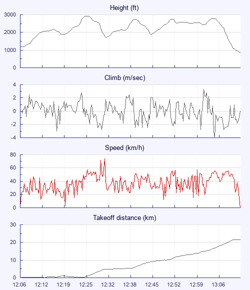
Clearly the climbs are coming off this end today, but it's not totally straightforward. A few pushes into wind find the best of it and after 10 minutes I'm at base… The base of airspace that is. It's mental torture taking yourself out of a perfectly good climb to avoid an infringement. Plus you've got to do it 200ft in advance since you never know what other lift you might hit, enforcing a hasty spiral. In the end I judge it nicely and I set off 80ft under Leeds Bradford's 3000ft CTA.
A few fields go by and all too soon it's definitely time to found a climb again. I find some zeroes next to Oakworth and this slowly builds into a climb once I'm through the slight inversion at 2100ft. There's plenty of time to think about how much of a constraint I've put myself in. I need to leave climbs at about 2700ft then find the next climb by 1600ft because the ground I'm going over is over 1000ft and the thermal needs space to organise itself. It's precious little height to work with.
There's a particular set of conditions you need to fly XC from sites under airspace. You need frequent climbs so a low cloud base helps. Very lifty air that's not going to rain so a northerly wind and drier airmass is ideal. Plenty of cloud gives you signs of lift but too much and it cuts off your energy. This is the Goldilocks bowl of XC conditions. I really should have found the time to do this flight over lockdown when Leeds Bradford had relinquished its airspace and I needn't have worried about all these picky requirements.
Second climb done and a glide over to Haworth. Brontë Parsonage, home of Emily, is directly below and I realise it's going to be a very memorable flight. Flying over places I know so well from the ground is a proper treat. I can look over Keighley to my home on Baildon Moor, see places I cycled to and took the kids to play their football matches. The memory and scenery is something I'm going to have to keep in my head though, I've forgotten to bring the camera, hey ho.
I'm on the new, to me, Omega X Alps and it's behaving nicely. It's taken a bit of getting used to the firmer ride but I'm beginning to dial into what it's telling me about thermal location and the glide is definitely a bonus. I need height again and after Haworth there's a combination of rising ground, quarry and dark heather. Textbook. I climb out over a caravan park and grass airstrip. My track takes me south whilst the windsock and surrounding turbines point west. Go figure.
I top out over Thornton Moor Reservoir and am treated to birds leaving the water to join a wide circling column over a kilometre to my west. It's tempting, but I'm already highish and the direction is into wind. The view here is of the towers of Manchester poking through the hills on my right and Leeds' to the left. Time to think about strategy. My optimistic goal was Nottingham at 100km. My thinking was, once you're passed airspace at 50km, the rest is easy, right? I do seem to be on track so my next targets are Halifax, the M62 and then onto the Huddersfield gap - a slot of airspace that will give me 500ft extra to play with. Oh the luxury!
There's a sustaining climb off Ogden Reservoir Country Park and I take it knowing descending ground is coming up. I leave, heading towards a reasonable cloud and rising terrain in the distance, but that is it. It's sink all the way, and when you've only got a thousand feet to play with you only need one hand to count the minutes until you're on the deck.
I pick Savile Park between Halifax and Salterhebble to land in as it's plenty wide and safe. It's next to the Wainhouse Tower and it seems fitting to end the flight at a tower having begun that way. A little over an hour in the air, 22km open distance and five climbs. A check of the tracklog confirms I wasn't in airspace. I've extended the site record to something acceptable now.
I do like my retrieves and there's three or four people come over to chat as I pack away. They all got a recommendation to look Dean up at Active Edge. A bus and train later, I trundle through Bradford amidst shoppers, gamblers and people doing a bit of afternoon preloading/heavy drinking… It probably makes the shopping more bearable.
Retrieve Photos including Piece Hall in Halifax.
The train drops me five kilometres from the hill and I get a pace on with my thumb out. I'm lucky and just at the foot of the big climb up Jamie and his son, Travis, stop to ask where I'm going. He was just on the hunt for an ice cream for Travis but was game to take back up the hill - that's another student coming your way now Dean! It rounds the day off nicely and I'm home in time for tea and to watch Obi Wan Kenobi with the lad.