Xc Title
User:Guest
Naviter advert
Andrew Craig  All flights
National League 2022
Flight type image
Turnpoint Flight on a Paraglider
Club
Southern
Glider
Gin Calypso
Date
2nd June 2022
Start
13:39
Finish
14:37
Duration
57mins
Takeoff
Golden Ball
Landing
Langley Burrell
Coords
Takeoff
51.37282, -1.82010
Start
51.37193, -1.81213
TP1
51.39730, -1.83085
TP2
51.43458, -1.96573
TP3
51.41987, -2.00912
Finish
51.48277, -2.09835
Landing
51.48242, -2.09823
Distances and Score
Leg 1
3.11k
Leg 2
10.26k
Leg 3
3.43k
Leg 4
9.35k
Total
26.15k
Score
26.2
Open Distance
Total
23.4k
Filename
Use full pilot name
Download
Validated
Yes
Flight map
Notes

This map gives an overview of the flight, using the turnpoints to plot the track.

Use the for a detailed map and flight track.

Duration 0:00   Takeoff Distance 0
Controls
To animate the flight: click a point on the track, use the slider, or click the Play button.
slider
slider
Speed
Speed
Slower
Faster
Track color
No data
Highlights
Track data
Time: No data
Height:
Climb:
Speed:
Interval:
Units
Height: metres
Climb: m/sec
Speed: km/h
Distance: km
chart
Notes

Climb and Speed averaged over 4 second intervals.

These values may be lower than those shown by a flight instrument, which has access to continuous raw data.

Metric units are used for all chart data, except for Height which is shown in feet.

Height   -   GPS data
Maximum Height
[14:07:46]
5098 ft
Lowest Save
[13:59:12]
3855 ft
Takeoff Height
[13:34:41]
869 ft
Landing Height
[14:37:47]
230 ft
Total Ascent 8031 ft
Height Gain
Above Takeoff 4229 ft
Maximum 4272 ft
Low Point
[13:45:24]
827 ft
High Point
as Maximum Height
5098 ft
Units
Climb   -   Pressure data
Maximum Climb
[14:06:01]
4.3 m/s
Minimum Climb
[13:58:05]
-4.0 m/s
Units
Speed
Maximum Speed
[13:56:53]
61.2 km/h
Average Speed
around course
27.1 km/h
Average Speed
over track length
36.6 km/h
Units
Tracklog
Flight Duration 1hr 3mins
Track Points 3787
Recording Interval 1 secs
Statistics Interval 4 secs
Track Length 38.5 km
Units
Flight instrument
Type Syride
Model Sys'Nav
Firmware 3.39
Notes

Climb and Speed averaged over 4 second intervals.

These values may be lower than those shown by a flight instrument, which has access to continuous raw data.

Average Speed around course is measured from Start to Finish points.

Track Length is the cumulative distance between track points from Takeoff to Landing.

You can change the default units displayed - see the Options page.

I thought the wind would be too east for Golden Ball until after the ban on flying from 1250 to 1330 for the jubilee flypast dispersal, but in fact it was southerly enough from early on. By the time I got to the hill, Jim and three others were already flying, with Steve Newcombe setting up.

Paul Jiggins (I think) got away first, followed by Jim and the other two, as Steve and I dropped out of the climb, and eventually had to land and wait. A couple of big military transports duly came past the front of the hill - mind you, they also went past the front of Milk Hill White Horse, which was not in the exclusion zone! Then they circled north of us, and finally departed eastwards.

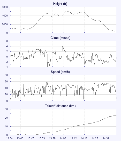
Zsolt and a couple more had meanwhile arrived, and we all launched at 1330. The sky had got a bit more organised, and we didn't have to wait long for a nice strong climbout.

At base, I got a little bit disconcerted at the greyness of the clouds to the east and north, and decided to head west, staying over sunny ground. In fact, there were no problems with going downwing - Zsolt got to Ross on Wye and Steve past Malmesbury.

My second climb, marked by sailplanes, took me over 5,000 feet, but I lost most of it gliding south-west to a cloud which didn't work properly. From then it was a glide towards Chippenham, with a failed attempt at a low save over a farm - over which a huge gaggle of rooks thermalled five minutes after I'd landed.

Walked into Chip, train to Bath, lift back from Lesley who was coming to Pewsey anyway. A nice day out.

Use this page to set various display Options. You can choose which units are used to display flight data, which map to show when the starts and which tab to show each time you view a flight.
Units settings

Metric units are used by default for the Statistics and XC Player pages, except for Height data which is shown in feet. You can choose your own custom settings here.

Height:
Speed:
Climb:
Distance:
  Use default
XC Player settings

When the XC Player starts, the track data is shown on the Hybrid map. You can choose a different map here.

Main Map:
  Use default
Tab settings

The first tab shown when you view a flight is the Flight Map. You can choose a different tab here.

First Tab:
  Use default
Notes

This page uses cookies to save your settings for future visits.

If you have disabled cookies for this site then any changes you make will not be saved.