Xc Title
User:Guest
Cloudbase Paragliding advert
James Lloyd  All flights
Condors PG League 2022
Flight type image
Turnpoint Flight on a Paraglider
Club
Condors
Glider
Ozone Rush 4
Date
20th March 2022
Start
11:53
Finish
15:38
Duration
3hrs 44mins
Takeoff
Kettle Sings
Landing
Nr Old Hall
Coords
Takeoff
52.07698, -2.33917
Start
52.08780, -2.32933
TP1
52.24493, -3.25428
TP2
52.46887, -3.62452
TP3
52.46040, -3.58603
Finish
52.46142, -3.63868
Landing
52.46122, -3.63817
Distances and Score
Leg 1
65.66k
Leg 2
35.46k
Leg 3
2.78k
Leg 4
3.58k
Total
107.48k
Score
107.5
Open Distance
Total
98.7k
Filename
Use full pilot name
Download
Validated
Yes
Flight map
Notes

This map gives an overview of the flight, using the turnpoints to plot the track.

Use the for a detailed map and flight track.

Duration 0:00   Takeoff Distance 0
Controls
To animate the flight: click a point on the track, use the slider, or click the Play button.
slider
slider
Speed
Speed
Slower
Faster
Track color
No data
Highlights
Track data
Time: No data
Height:
Climb:
Speed:
Interval:
Units
Height: metres
Climb: m/sec
Speed: km/h
Distance: km
chart
Notes

Climb and Speed averaged over 4 second intervals.

These values may be lower than those shown by a flight instrument, which has access to continuous raw data.

Metric units are used for all chart data, except for Height which is shown in feet.

Height   -   GPS data
Maximum Height
[15:03:14]
4573 ft
Lowest Save
[14:00:03]
1827 ft
Takeoff Height
[11:30:20]
1119 ft
Landing Height
[15:38:55]
1299 ft
Total Ascent 31325 ft
Height Gain
Above Takeoff 3455 ft
Units
Climb   -   GPS data
Maximum Climb
[12:29:16]
6.5 m/s
Minimum Climb
[15:30:08]
-4.5 m/s
Units
Speed
Maximum Speed
[12:15:36]
73.8 km/h
Average Speed
around course
28.7 km/h
Average Speed
over track length
41.0 km/h
Units
Tracklog
Flight Duration 4hrs 8mins
Track Points 14916
Recording Interval 1 secs
Statistics Interval 4 secs
Track Length 169.9 km
Units
Flight instrument
Type Huawei Mrd-lx1 9
Model Not Set
Firmware 0.9.5.3
Notes

Climb and Speed averaged over 4 second intervals.

These values may be lower than those shown by a flight instrument, which has access to continuous raw data.

Average Speed around course is measured from Start to Finish points.

Track Length is the cumulative distance between track points from Takeoff to Landing.

You can change the default units displayed - see the Options page.

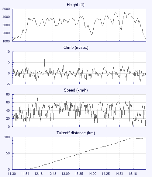
A few of us saw this day coming but didn't think it would go so well. Many other pilots on take-off and windy on top of ridge. I was 2nd pilot to take off and first to leave the hill at 1000m and was soon at cloud base at front of the cloud. Then I waited for more to join me and cloud to appear downwind. Was soon overtaken by a red rook3 and then another one. Just kept going with them finding more and more climbs frog leaping and spreading out to survive. Plenty of apparent climbs nearby thankfully. The dots were connecting. I was passed by a few seasoned pilots but stayed together in the gaggle included Ben & Gerry. We followed Gerrys set waypoints loosely which was a first for me. When I separated from the two at one point I got low in a tricky spot. Had to commit and found a rowdy climb re-joining the others. Then Gerry shot off into the blue and I reluctantly followed him connection with a forming street near him. Gerry went down slowly and landed at the end of a small long road. I hung around a bit enjoy the view then trying to loose height on ears. Eventually found him from some directions from below. Gently landed by him thinking we had only done 60km. Turned out to be a bit more. Ben carried on but it was switching off soon by now. After some great work by Gerry we managed to get a taxi back with some other pilots. One had made it to the coast! Went we got to the pub we were greeted with cheering Condors pilots which had a great day too. What a way to start the season! My furthest flight by far.

Use this page to set various display Options. You can choose which units are used to display flight data, which map to show when the starts and which tab to show each time you view a flight.
Units settings

Metric units are used by default for the Statistics and XC Player pages, except for Height data which is shown in feet. You can choose your own custom settings here.

Height:
Speed:
Climb:
Distance:
  Use default
XC Player settings

When the XC Player starts, the track data is shown on the Hybrid map. You can choose a different map here.

Main Map:
  Use default
Tab settings

The first tab shown when you view a flight is the Flight Map. You can choose a different tab here.

First Tab:
  Use default
Notes

This page uses cookies to save your settings for future visits.

If you have disabled cookies for this site then any changes you make will not be saved.